As an aquifer declines, farmers hope for water promised 80 years ago.
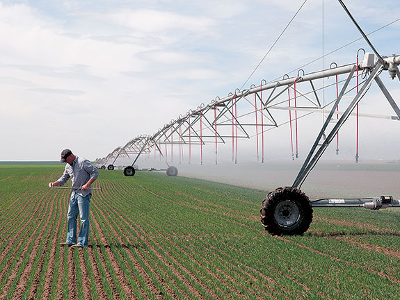
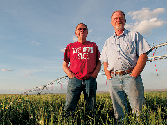
LAST SUMMER as we stood in the middle of Brad Bailie’s onion fields just north of Connell, the discussion, as discussions seem to do in the Columbia Basin, turned to water.
Bailie ’95 pumps irrigation water from a well drilled down 800 feet. Neighbors have pushed wells down to 2,000 feet. At such depths, the water is often laden with salts and minerals. After a while of irrigating with this water, a crust can form over the soil surface. Farmers must use a variety of means to break up the crust, including acid, so the irrigation water can soak in.
Since he farms organically, Bailie is limited in what he can use to break up that mineral crust. He also expresses discomfort with mining the ancient water.
Indeed, after years of continuous pumping throughout what is called the Odessa Aquifer, water levels have dropped precipitously. In some areas of the aquifer, water levels have been dropping about 10 feet a year.
Not only is irrigation threatened, so too are the municipal water supplies of 20 towns throughout the region, including Connell, just to the south of Bailie’s onion fields.
Bailie nods toward the horizon. That’s the end of the East Low Canal over there, he says. A tantalizing few miles away, the East Low looks to many of the area’s farmers the only promise of continuing their irrigated livelihoods.
Short of reverting to dryland farming, farmers across what is termed the Odessa Subarea of the Columbia Basin Project are counting on the federal promise, rooted in FDR’s New Deal now 80 years distant, to someday complete the project’s full potential.
Now the Bureau of Reclamation, the federal agency responsible for managing water across the western United States, and for building the Grand Coulee Dam and the Columbia Basin Project, has announced its plan to partially expand the project, for a price of $11,800 per irrigated acre and a total cost of more than $800 million.
THE COLUMBIA BASIN PROJECT is a network of canals, dams, reservoirs, laterals, wasteways, and ditches designed to carry water from the Columbia River to irrigate more than a million acres of the Columbia Basin. Built over a period from before 1946 until after 1966, the project was, as Paul Pitzer points out in his excellent Grand Coulee: Harnessing a Dream (WSU Press, 1994), “an accomplishment larger in size, more complicated in engineering, and more costly than Grand Coulee Dam, the project’s key feature.”
It takes a while to grasp just how big the Columbia Basin Project is. Even presented directly with the evidence, as I am on an April day, with maps and figures and a personal tour of a sizeable fraction of the project, the largest irrigation project in the United States challenges the imagination as much as the vastness of the Columbia Basin landscape itself.
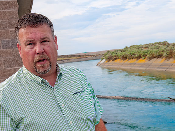
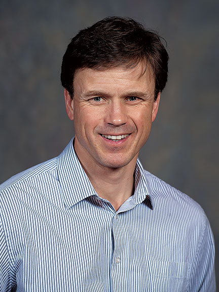
After 18 years as manager of the East Columbia Basin Irrigation District, one of three districts responsible for managing the Columbia Basin Project’s water, my guide, Craig Simpson ’90, continues to marvel not only at the geographic scale of the project, but also at the capability and genius of the people who conceived and built it.
“As an engineering geek, when I came here, it was a good job,” he says. But as he learned the specifics of a system designed to deliver water to more than a million acres, the marvel of this engineering phenomenon sank in. “Those engineers had their act together,” he says.
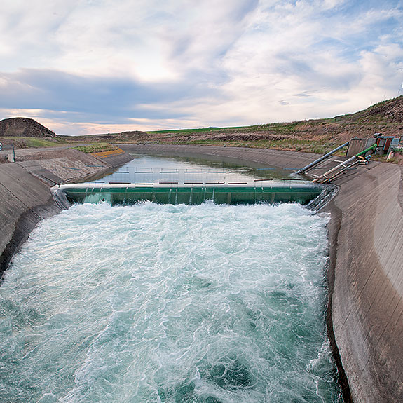
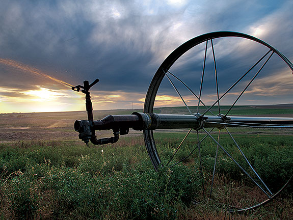
Crossing the East Low Canal, just outside of Othello, and just north of Brad Bailie’s onion fields, where one of the project’s main arteries nears the end of its 87-mile delivery of water, gives little hint of the project’s magnitude, even if you know that the irrigation sprinklers visible from State Route 26 are pumping water diverted from the Columbia River 50 miles to the north and directed through miles of canal and pipeline. The East Low begins its delivery with a capacity of 4,500 cubic feet per second. By the time it reaches State Route 26, it has already delivered 4,200 acre feet of water to a land rich in soil but poor in rainfall. An acre foot is the amount of water it takes to cover an acre one foot deep, about 326,000 gallons.
Columbia River water becomes Columbia Basin Project water when, with six 65,000-horsepower and six 67,500-horsepower pumps powered by generator turbines in the Grand Coulee dam, it is pumped 280 feet up from Lake Roosevelt to Banks Lake, the holding, or “equalizing” reservoir. Banks Lake was created by damming both the north and south ends of the 27-mile-long Grand Coulee, which was formed by ancient floods. Banks Lake has a storage capacity of 715,000 acre feet.
From Dry Falls Dam, at the south end of Banks Lake, the water flows into the Main Canal and then into the West and East Low canals. Altogether, Columbia Basin Project water flows through 300 miles of main canals, 2,000 miles of lateral canals, and 3,500 miles of drains and wasteways.
As large as it is, though, the Columbia Basin Project was never finished. A combination of higher than expected costs and the withdrawal of farmers on its eastern edge put its completion on hold for the last 60 years.
Altogether, surface water has been supplied to about half of the intended 1,029,000 acres promised in the original plan. Farmers in the Odessa Subarea, which is included in the project but never received surface water, were eventually given temporary permits to pump from deep wells.
Now, as a proposed antidote to the declining Odessa aquifer caused by that “temporary” deep-well pumping, the Bureau of Reclamation is proposing to extend the project’s reach.
The process toward reaching a decision on pursuing such a project is obviously long and tortured. But after numerous studies, reports, and environmental impact statements, in April, the week before my visit with Simpson, the Bureau of Reclamation released its long-anticipated “Record of Decision.”
In the 25-page statement, the bureau announced its choice of “Modified Partial-Replacement Action Alternative 4A.” If developed, Alternative 4A would provide Columbia Basin Project surface water to 70,000 acres of Odessa Subarea land currently being irrigated from deep-well groundwater. Once water is provided, those wells would be placed on standby status.
The proposal includes enlarging the East Low Canal south of I-90 and adding second barrels to five existing siphons. It would also create a pressurized pipeline system to deliver the water to fields. This would include pumping plants, approximately 150 miles of buried pipeline, various monitoring stations, and 150 miles of electric transmission lines.
Reasons given for selecting Alternative 4A include the most benefits to the area with the least impact on other environmental resources. Also, at the estimated cost of $11,800 per acre irrigated, Alternative 4A is the cheapest.
The Columbia Basin drew waves of settlers in the early twentieth century eager to homestead the fertile, but dry, land. Where some had succeeded earlier with cattle, newcomers made an impressive start with dryland wheat. But the climate was fickle. A few years of drought forced many to give up.
Concerned with the depopulation of the area, local businessmen conceived audacious schemes. Rufus Woods, owner of the Wenatchee World newspaper, became the champion of a dream to dam the upper Grand Coulee.
A tireless promoter, Woods joined other Columbia Basin dreamers to finally capture the imagination of the other Washington, making a great dam and irrigation project a key part of the New Deal.
“In 1933, when the New Deal assumed the project,” writes Pitzer, “it took the vision of the agricultural/industrial empire and added the dimension of planning. President Roosevelt encouraged planning at the federal level and appointed advisors and cabinet members with similar views… In its early stages, the New Deal planners wished to create organized rural communities, and they intended to plan from the top down with guidelines coming directly from leaders at the federal level.”
Their goal for the Columbia Basin was what historian Richard Lowitt called “The Planned Promised Land.”
This was Progressivism at its boldest. The Grand Coulee Dam would back and divert the Columbia River to irrigate a rich land lacking only water and provide small farms to farmers displaced by the Dust Bowl, populating it with small but vibrant planned communities. The beneficiary of the project would be the small farmer. Indeed, farmers would be limited to 160 acres.
Even though the original idealism had faded, perhaps the culmination of the original idea was realized in “Farm-in-a-Day” in 1952. To mark the first delivery of water to the Columbia Basin Project, promoters determined to build and plant an 80-acre farm near Moses Lake, complete with irrigation, of course, and give it to the most deserving veteran of either World War II or the Korean War. He and his family would be given a fully functional farm, created in a 24-hour period.
Donald Dunn, a veteran of World War II and a dryland farmer from Kansas, was chosen through a search by the Veterans of Foreign Wars. In the spring of 1952, 70 pieces of heavy equipment and 34 tractors leveled, tilled, and planted the land. Crews began building the house and outbuildings.
At 4:30 that afternoon, Bureau of Reclamation commissioner Michael Straus opened a valve to begin irrigating one of the farm’s fields. “Here this afternoon we celebrate the addition of the equivalent of a new state to the union,” he told the gathered crowd, alluding to the fact that the Columbia Basin Project was comparable in size to Connecticut or Rhode Island.
Within two years, however, Dunn, unable to secure loans or otherwise make a living on 80 acres, sold the farm and moved back to the Midwest.
As Paul Pitzer points out in an article for the Pacific Northwest Quarterly (January 1991), Dunn was not alone in his failure. “Of 725 units sold by the government from 1952 through 1956, 16 percent changed ownership during that period; another 106 parcels went unsold.”
Increasingly, farmers rented additional land or consolidated land by registering it under the names of other family members. In 1982, the Reclamation Reform Act legalized that consolidation by allowing each project owner 960 acres.
About the same time as the Farm-in-a-Day was being built, Orman Johnson’s father started growing potatoes near Othello, though his Washington roots are much older. His grandfather Reaugh graduated from Washington State Agricultural College in 1906 and wrote his senior paper on irrigation, then helped develop irrigation around Chelan.
His father’s family, originally from Sweden, moved to Washington from California the same year Reaugh graduated from Washington State.
With his brother Gavin and nephew Nick, Johnson ’69 farms 6,000 acres, irrigating from deep wells, just outside of Othello. The big “Go Cougs” potato storage shed east of Othello belongs to the Johnsons.
“We got our first well permit in 1964,” says Johnson. “The assumption was that the Columbia Basin Project would be finished in a few years.”
Under that assumption, that the wells would be temporary until the project was completed, many wells were drilled in the 1970s.
And the water level started dropping, he says.
In the 1980s, the Johnson wells could pump 10,000 gallons a minute at the beginning of the growing season and 8,500 by the end of the season.
“Now,” he says, “they start out at 6,000 gallons a minute and end with some wells not producing in August or September.”
The Johnsons plant late-season crops like onions and potatoes according to how much water they think they will have left in August and September. Over the last decade, they have reduced the amount of onions and potatoes they grow simply because they don’t have enough water left by the end of the season.
In addition, says Johnson, echoing Bailie, “The deeper you go, the poorer quality the water is.”
The Johnsons’ wells are 2,200 feet deep, and they are pumping from 900 feet.
In spite of the shortage, “We’ve decided not to drill deeper.”
“My dad was on the irrigation board in the ’60s and ’70s,” says Johnson, who himself is currently on the board of the East Columbia Basin Irrigation District. “He thought we were going to have expansion back then.
“The situation is getting scary,” he continues. “We’re losing production every year, which affects all the industries. If a number of these farms went dry, processors would have to find their crops from some other acres.”
Not only are communities such as Connell and Othello concerned about their water supplies, they are also nervous about losing their businesses and livelihood.
Like others in the Basin, Johnson does not see expansion of surface irrigation as optional.
“Look at what we can grow here,” he says. “There is no place in the world that can grow as many tons of potatoes per acre.”
Besides its rich soil, the Basin has a long growing season, far enough north that it has more hours of daylight than, for example, southern Idaho. Other potato growing areas, Maine and Michigan, have the same hours of sunlight as Washington, but have a shorter growing season because they cannot get into their fields as early.
“So this is the place to have water,” he says.
Among the alternative scenarios offered by the Bureau of Reclamation to offset the decline of the Odessa aquifer was one that is required of such reports: that of no action.
In typical projects, says irrigation district manager Simpson, a “No Action” alternative would simply mean that the situation does not get better, that somebody does not get something they want. But in this case, he argues, it’s pretty easy to document how bad things can get if there is no action.
No action would have a huge cost, he says. If the expansion of surface water irrigation were put off, landowners would go out of business and the local economy would take a huge hit.
“If you go talk to the processing plants, they’re concerned,” he says. “They’re not doing expansions because of the uncertainty of what’s going to happen.”
Regarding the bureau’s proposal, Simpson says, “Maybe I drank from the goblet too long, but it just seems common sense to me.”
Agricultural revenues in the Columbia Basin, largely made possible by irrigation, totaled $1.44 billion in 2008, according to the Columbia Basin Development League. Even so, critics have argued that the balance sheet simply doesn’t balance. Revenues will never match expenditures in a project so grand, say some economists, who narrow the difference to a benefit/cost ratio.
Critics of expansion note two main problems. One is whether the benefits of the projects will outweigh the costs. The other is the matter of who pays.
Jonathan Yoder, WSU professor of economics, has reviewed economic analysis by the Bureau of Reclamation and questions the very basis of their results. “Their modus operandi seems to be to start with that cost and figure out ways to get the benefit estimates up.”
He also questions how water is valued in the bureau’s analyses. In an earlier review, bureau economists valued water at $21,000 an acre. “The average difference in eastern Washington between irrigated land and dry land value is around $4,000,” says Yoder. “The value of ag land rental rates and market prices reflect the value of water for production, so [the bureau analysis] is overstating the value by about $17,000.”
Norm Whittlesey and Walt Butcher, professors emeriti of agricultural economics, have a long history of questioning the value of expanding the Columbia Basin Project. In general they base their criticism on the fact that in order for a project to be justified, bureau rules dictate that it must show a benefit/cost ratio of at least 1.0.
Although the Columbia Basin Project was officially authorized in 1935, its development was interrupted by World War II. The Grand Coulee Dam provided an opportune source of the massive amounts of electricity necessary for two key parts of the war effort: the aluminum industry, essential for production of airplanes, and Hanford, where plutonium was produced for one of the two bombs dropped on Japan.
So it was not until the late 1940s that the dam’s original purpose, irrigation, was revisited. By the mid-1960s, the first half of the project, the funded half, was essentially finished.
Toward the late 1970s, Washington’s powerful senators, Henry “Scoop” Jackson and Warren Magnuson, “greased the skids” for federal funding for the second half of the project. However, both the Carter and Reagan administrations insisted on the state’s contributing to the project, and Carter actually tried to kill the project altogether.
In the early 1980s, the Washington legislature gave Whittlesey a grant to study the benefits and costs, assuming that the results would come out heavily in favor of more irrigation. With no reason himself to think otherwise, Whittlesey designed a study, involving a number of colleagues both at WSU and the University of Idaho.
“By the time we finished,” says Whittlesey, “it became apparent that costs, even that the state was asked to contribute, far exceeded the potential benefits.”
In 1984, the state senate published a budget to provide state money that would allow the federal money to be spent on expanding the project.
Approval depended only on the passing of the House version.
“To make a long story short,” says Whittlesey, “I presented my side of the story to the House budget committee.”
Whittlesey finished his testimony about 8:00 that evening and rushed to catch a plane, fully believing that his testimony had been ignored. After all, the house already had the funding written into its budget.
Much to his surprise, however, the chair of the House budget committee called him the next morning to tell him that the House had pulled the funding out of its budget.
The uproar was immediate. The federal government announced it could not fund the project without state participation, and proponents of the project leveled their anger at Whittlesey, to the point of trying to have him fired.
“It wasn’t just me,” he says. “I always made sure we had peer review… Fortunately, I had tenure.
“Most of what I did around here,” he insists, “was favorable to agriculture.”
Indeed, Whittlesey, who retired in 1996, enjoyed a long productive career in agricultural economics, with many accolades.
It just happened that his concentration was water, a most troublesome subject indeed.
Whittlesey’s critique of the current proposal is no less withering than his testimony in 1984. But this time, it’s been effectively ignored. Which has him exasperated.
“They’re not going to get federal money,” he says, “the state doesn’t really have the money and shouldn’t be funding it, and the farmers can’t afford it.”
Regarding Whittlesey’s first point, federal funding would require a GAO benefit/cost analysis that would figure in lost hydropower involved in pumping the water to Banks Lake.
Lost hydropower will, says Whittlesey, amount to $300 worth of energy cost per year per acre.
“That’s more than the net revenue coming off land,” he says. “That’s another tax on you and me through utility rates. Nobody talks about that.”
The question of who would actually pay for the Columbia Basin Project was a problem from the beginning, argues Pitzer in Grand Coulee: Harnessing a Dream.
“Without the link to power and its direct subsidy,” he wrote in 1994, “plus additional subsidies from the government, such as its assumption of interest charges, the project could not exist.”
In short, whereas the Bureau of Reclamation figures the benefit/cost ratio at just over 1.0, Whittlesey and Butcher, once they corrected what they perceived as erroneous figures, estimate the ratio at 0.1.
Supporters of the project’s expansion, however, insist that benefits far outweigh the costs, because the costs have been overstated.
“The Bureau puts in things way too high,” argues Orman Johnson, “which is why it is difficult to get the benefit/cost ratio.”
As an example, he points to the Weber Siphon project a couple of years ago. A siphon is simply a pipe that will enable a canal to cross a lower level of land without diverting from as straight a course as possible. Although expensive, they are much less so than building a canal according to the landscape.
The Bureau’s estimate for building the siphon under Interstate 90 as $57 million, says Johnson. The bid was actually $22 million, and the cost ended up in the low thirties.
Farmers will also have the option of taking the new surface water or continuing to pump, he says. Not including all lands on the pipeline makes the ratio higher.
Simpson agrees that the costs have been overstated. Also, he strongly disagrees with Whittlesey and Butcher’s inclusion of lost power generation.
“How do you figure lost power generation when they [Bonneville Power Administration] don’t have a right to it?” he asks.
“I think this is a fairly balanced approach.”
“The economics of the Columbia Basin Project involve an intricate mix of hydroelectric power, irrigation, recreation, wildlife, navigation, conservation, agricultural surpluses, and Native American rights,” wrote Pitzer in 1994. “Furthermore, these aspects of the project do not exist in a vacuum.” Indeed, these interactions and needs have become even more complex over the last 20 years and will only increase in complexity with growing power needs, agricultural needs, and so forth. Add to this the approaching reassessment of the Columbia River Treaty between the United States and Canada, which will surely lead to changing flows and power needs. And then there is climate change and the possible effects on river flow and agriculture and many other factors.
The Water Research Center at WSU produced a report in conjunction with the Washington Department of Ecology in 2011 that assesses projected water needs in the coming decades, including effects on agriculture. One of the most interesting projections, based on computer modeling, is that the Columbia Basin will become a little wetter. As a result, director Michael Barber argues that the return of some areas, particularly in the Odessa Subarea, to dryland wheat will be far more cost-effective than the $11,800 an acre price tag attached to Alternative 4A.
On the other hand, says Barber, even if we accept the high cost of taking water to the Odessa Subarea, he worries the approach is self-perpetuating, that fluctuations in Banks Lake will lead to outcries from recreational users, leading to a proposal to build another reservoir, with a price tag in the billions. Indeed, that reservoir has already appeared in alternative proposals, with no suggestion of how it might be paid for.
John Sirois, chair of the Colville Business Council in Nespelem, 20 miles north of Grand Coulee Dam, condenses tribal concerns over the project’s expansion to possible fluctuations on Lake Roosevelt and effects on cultural resources, the effect of changing flows on the tribe’s new salmon facility at Chief Joseph Dam, and the general effect on what he calls the Columbia’s “integrity.” Besides, he says with a wry smile, wouldn’t it be nice if we got some irrigation up here?
The extent of the controversy over the project’s expansion and the accompanying complexities exemplify issues regarding the future of water use and availability in Washington and throughout the West and raise many questions: What is the best use of this extraordinary resource? What is the greater good? How shall public expenditure be allocated? And who, exactly, pays?
Web Extras
The Columbia Basin Project’s past and present