RECOLLECTING WASHINGTON’S LANDSCAPES
Richard Scheuerman ’73 has driven us down a long gravel road to the Palouse River to show me a couple of old settlements and the outline of the Kentuck Trail. The scar of the old trail, which once led hopeful miners to the new gold fields in Montana, angles up the bluff across the river, toward the present day world. Down here by the river, we have entered an earlier place.
It is absolutely still down here in the river valley on a crystalline October day, still except for the occasional magpie and the soft murmur of the Palouse and the ghosts that Scheuerman has evoked. To journey down to the Palouse with Scheuerman is to be immersed in his landscape. His Volga German ancestors immigrated to the Endicott area in the late 1800s. They and other families still populate the area.
This is but a shallow immersion, however. Scheuerman’s many books do not begin with European exploration and settlement, but are often about the interaction of European settlers and the region’s native peoples. Even his most recent, Harvest Heritage, written with Alex McGregor, which purports to be about “the agricultural origins and heirloom crops of the Pacific Northwest,” embraces native participation. Scheuerman can never exclude the pertinent detail, the context, the predecessors, the meaning.
The Palouse River was a thoroughfare for the native people, he says. After European settlement, they regularly met up at the DeLong farm, upriver, toward St. John.
Growing up, Scheuerman wondered who these people were, this parallel culture alongside the growing European settlement.
Having determined to go to the source, one day while he was in high school, Scheuerman and his grandfather drove north to Nespelem, the headquarters of the displaced Colville Confederated Tribes. He announced himself to a tribal secretary, Annie Cleveland George, who directed him to Arthur Tomeo Kamiakin, who gave him the first of a priceless trove of oral histories Scheuerman has gathered from native elders over the years.
Scheuerman’s eastern Washington landscape is rich with stories, of his ancestors trading fruit for salmon from the local Indians, of Norwegians and trappers, of Chief Kamiakin and Washington State College scientist William Spillman. All are part of the dense landscape that he narrates.
“It’s a magical place,” he says as we arrive at another part of the valley, a site that still shows the remains of the settlement he fictionalizes in “The Rainbow Bridge,” one of a series of short stories about the Volga German settlers.
“One of the Ochs family, who had a beautiful voice, he would climb the bluff in the evening and just sing.”
Cataclysm, Light, and Passion
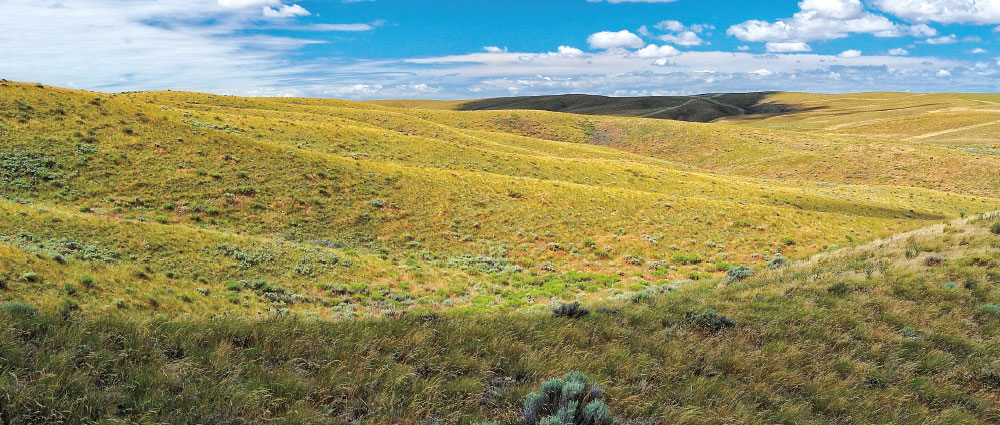
If there were a scientific way to measure the grandeur and diversity of landscape within a given area, Washington has the stuff to rival any region in the world. But diversity and grandeur are only a part of that landscape’s appeal.
Lovely and unusual as the Palouse hills and its river canyons may be, their deeper beauty emerges only as we learn to interpret their various stories. That, looking backwards, the European migration is but a brief prelude. That the native people, the Palouse and Nez Perce, were here for thousands of years and had summer camps all along the rivers. That the hills themselves are but brief, that they blew in over thousands of years as glacial silt deposited by the unimaginably catastrophic Missoula Flood. That there have been many landscapes here, both physical and temporal. Indeed, if it is the spatial element that gives landscape its body, so to speak, it is the temporal, its story, that gives it its soul.
Scheuerman is a devout member of that society of storytellers and interpreters—historians, ecologists, geologists, archaeologists—who invest Washington’s landscape with meaning. Once largely relegated to painting and the study of geography, the idea of landscape is increasingly being adopted by a variety of disciplines as a way of understanding our context.
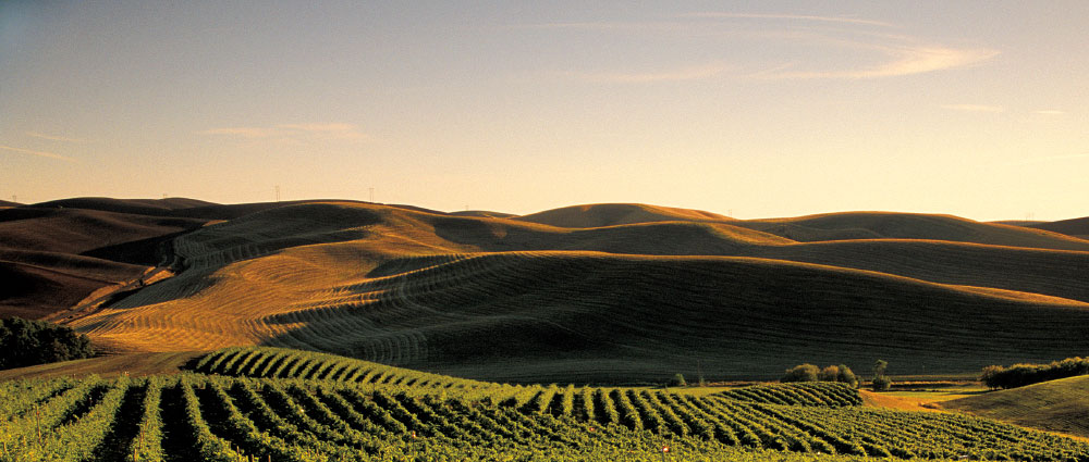
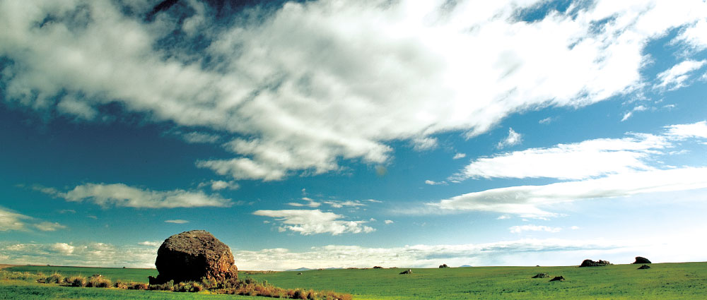
Historian Rob McCoy has begun to examine how wine has transformed the landscape of eastern Washington, particularly the Walla Walla area. Washington currently has about 43,000 acres planted to wine grapes. Although that is a mere fraction of the state’s 14.9 million acres of farmland, the impact of wine on the landscape is profound, starting with the careful geometry of the trellised rows, lending the taste of its terroir to palates and imaginations throughout the world.
Although the southeastern Washington landscape is still dominated by the wheat that first supplanted the sagebrush and bunchgrass, vineyards have further Europeanized our wild western hills.
The first vinifera grapes were probably planted by the Hudson’s Bay Company at Fort Vancouver in 1825, and French trappers may well have planted wine grapes in the Walla Walla Valley. However, no one really imagined the transformation of the landscape until Walt Clore, Chas Nagel, and others started experimenting.
Clore joined Washington State College in 1934 and was appointed assistant horticulturist at the Prosser research station three years later. Whatever it was that stirred his imagination, Clore immediately began planting wine grapes in variety trials. Convinced though he was of Washington’s suitability for wine grapes, however, his vision would not be realized until Chas Nagel arrived in Pullman in 1960. A microbiologist, Nagel arrived from the Napa Valley with a vision of a wine landscape.
In an interview for our first issue in 2001, Nagel recalled touring the state with Clore, talking grapes with farmers, exploring the next phase of Washington’s agricultural landscape. Clore had variety trials of vinifera growing all over the state.
“Walt was Johnny Grapeseed,” said Nagel. “It was a wonderful time.”
Though Clore, Nagel, and a few adventurous farmers understood the capacity of the landscape and climate for producing wine, it was Larry Meinert and Alan Busacca who explained the deeper, most elemental aspect of the landscape that would produce Washington wine.
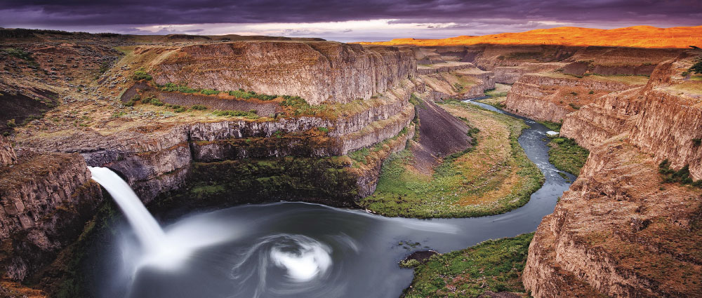
In “Terroirs of the Walla Walla Valley appellation,” Meinert, a geologist, and Busacca, a soil scientist, both with Washington State University at the time and wine devotees, took eastern Washington’s terroir deeper than amount and timing of rainfall, or the aspect of slopes and amount of heat units and temperature swings. They took our understanding back to the Flood.
When a massive ice dam containing the enormous Glacial Lake Missoula broke 15,000 years ago, a wave 500 feet high swept south across eastern Washington at 50 miles an hour. Two thousand five hundred cubic kilometers of water, with a flow 10 times greater than the combined flow of all the rivers in the world, scoured the land to its bedrock foundation. This catastrophic event repeated itself as many as 90 times, as the ice dam formed and failed every 35 to 55 years.
The sediments scoured by the floods settled out and then were carried back north by the prevailing southwest winds, resettling approximately along the floods’ path.
“This windblown silt deposited over the underlying volcanic basalt, layered with the ash of intermittent eruptions of Northwest volcanoes from Mazama to St. Helens—this is the literal grounding of Eastern Washington’s terroir,” they wrote.
The flood story had been puzzled out in the 1920s by the legendary geologist J Harlen Bretz. Meinert and Busacca helped us understand the ancient landscape genesis of what we sip.
Rick Small ’69, one of the first farmers in the area to recognize the landscape’s potential for wine and founder of Woodward Canyon, understood the basis.
“This is great soil,” he said in an interview for our first issue. “I would not be anywhere else in the world.”
First Inhabitants
What has made much of Washington’s agriculture possible, what has helped create a garden out of a desert, is irrigation—irrigation and cheap hydroelectricity for pumping made possible by dams. Those dams, however, particularly the Snake River dams, obliterated much of the canyon landscapes, including hundreds of village and burial sites.
This destruction, ironically, greatly magnified our understanding of the region’s cultural landscape. Money flowed from the federal government to salvage archaeological sites that would soon be under water.
The Marmes Rockshelter was one of those sites. In the late 1960s, Richard Daugherty, Carl Gustafson, Roald Fryxell, and other faculty and graduate students worked desperately through a harsh winter to glean what they could before the floor of the cave disappeared beneath the dammed Snake’s water.
The Marmes shelter is located near the mouth of the Palouse River, where it joins the Snake. Bill Andrefsky, an archaeologist who specializes in lithic technology, or stone tools, cites Marmes in explaining the evolution of archaeology toward an appreciation of the landscape.
“The whole concept of landscape archaeology,” he says, “has burgeoned from a very small field that looks at settlement patterns or analysis from a spatial level to one where landscapes not only provide resources for food and how people use the land over time to one where the landscape is part of why people select to live in certain locations, has political meaning, has religious meaning, has all of these other kinds of meaning.
“One of the most interesting things I’ve come to start believing in,” he continues, “there are certain spaces, locations out there, places that are very special, and people live there, not only their entire lives, and their immediate family’s entire lives, but people lived there for thousands and thousands of years.”
For thousands of years, residents of the Marmes rock shelter led their lives and buried their dead. Excavation, as far as the archaeologists were able to accomplish, pushed occupation at the shelter back more than 9,000 years, which is considerably older than was thought at the time to be the oldest occupation in the United States.
What intrigues Andrefsky is what kept people at the site for all those thousands of years. Yes, it was a great shelter, at the confluence of two rivers. Food was bountiful.
But Andrefsky feels there is something even more special about the Marmes landscape, maybe simply something we haven’t yet discovered.
“Those rocks that were laid down there during the Columbia Basalt lava flows haven’t changed much in the last 12,000 years,” he says. “That landscape, that vista, is pretty much the same. Maybe the vegetation is different, but definitely that landscape was there.”
Landscape Is Us
“Landscape ecology as a discipline,” says landscape ecologist Mark Swanson, “if you care to define it in a very liberal sense, goes back to our hunter-gatherer ancestors. They had to understand things at a landscape scale in order to escape harsh weather or escape predators or find water.”
Ptolemy, Pliny the Elder, and Pliny the Younger all thought and wrote about how landscapes are structured, he says. But the term was not coined until German geographer Carl Troll introduced the term as part of his work, which consisted of using aerial photography to interpret interactions between environment and vegetation.
The European school of landscape ecology grew out of this work and focused largely on the settled environment. The discipline’s interaction of process, pattern, and scale occurs at four primary levels.
First is the geophysical, says Swanson, the topological and lithological. What kind of rocks gird a landscape? For example, granite decomposes as acidic, while limestone decomposes as basic, either of which affect large-scale outcomes such as plant community composition.
Second is the available biota: the plant, animal, and microorganism population of an area.
The third level of interaction is disturbance: windstorms, the Missoula Flood, forest fire, Mount St. Helens.
Finally, there is us. Even though we are part of the available biota and are certainly a disturbance, says Swanson, “We are unique in global coverage.”
Of Time and Wildness
Bob Mierendorf understands that last premise quite well.
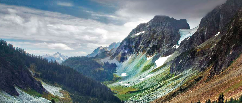
“This landscape is my PhD,” he said when I first interviewed him about his work in the North Cascades and the upper Skagit River. “I call it Upriver University. A 3-million-acre campus. Colors are green and gray. On a really good day it’s all gray.”
Mierendorf never finished his doctorate at WSU. “They gave me the tools,” he said. Rather than complete his dissertation on campus, he became the first National Park archaeologist in the Pacific Northwest. He set out to reveal the remarkable landscape that reaches along the very wet upper Skagit and up, up to the reaches of the North Cascades, some of the most dramatic landscape in the world.
As well as the most misunderstood.
“Wilderness never existed until 1964, when Congress created it,” said Mierendorf. Contrary as he can be, though, he has no beef with wilderness management. He just doesn’t like intellectual bias. Wilderness implies that it has always been free from human contamination. North Cascades National Park was created as a wilderness park.
When Mierendorf started at the park in 1984, archaeologists had documented a total of 17 archeological sites, including the remarkable Newhalem rock shelter, just a short walk off the highway near Marblemount. Such discovery did nothing, however, to negate the nearly universal belief that native people never went into the high country, but rather stayed in the lowlands. What little interaction existed between peoples east of the Cascades and west of the Cascades must have been accomplished by a very long roundabout journey.
Since then, he has identified 300 more sites, 45 of which were located between 4,000 and 7,000 feet. The high country seems to be where the local folks went for the summer. And more than that.
“Cascade Pass easily makes the short list of the most beautiful places in the world,” I wrote upon hiking to the pass with Mierendorf. “The pass is a saddle between drainages. The east side is the watershed of the Stehekin and Chelan rivers, which flow to the Columbia. The west side is drained by the Cascade River, a tributary of the Skagit. Peaks around us range between 8,200 and 9,200 feet. Forbidden Peak. Mount Formidable. You get the picture.”
The idea that Indians did not travel up here is understandable, at least to the exercise averse, which most archaeologists are not. Even so, it’s tough going.
But Mierendorf has shown that Cascade Pass was a veritable Grand Central Station back in the day. Back as far as 10,000 years.
This landscape may be wild, Mierendorf argues, but it is no wilderness.
The Home of My Family
Ed Claplanhoo really didn’t understand at first what the young hippie teacher was trying to tell him over the phone in the winter of 1970. That “people” were taking “artifacts” from the “house.”
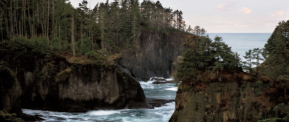
As chairman of the Makah tribe, Claplanhoo kept close track of things and knew his territory well. The persistent pleas from the teacher made no sense. But then, finally, he realized it was not Neah Bay, current home of most Makahs, that the young man was talking about, but Ozette, an ancestral village down the coast, on Cape Alava, reachable only by boat or a four-mile hike from the nearest road.
Until archaeologist Richard Daugherty set out in the late 1940s to explore the Washington coast, no systematic survey had yet been done of archaeological sites. One of the sites he noted was Ozette, and in the late ’60s, he began a preliminary excavation. But diverted by the Marmes excavation back in eastern Washington, and convinced that the Ozette site was exceptional and would need full-blown attention, he returned to more urgent work.
Makahs had lived at the Ozette site until the 1920s. But oral history told of an older village that had been buried by a landslide, probably when a magnitude 9 earthquake released the saturated hillside above it in 1700.
In 1970 a winter storm uncovered a longhouse.
Now, forty-some years later, if you hike the four miles from Ozette Lake down to the coast, you will find no trace of the village or the 11-year excavation that revealed an extraordinary wealth of knowledge about the Makahs and the coastal landscape. Their ancestors had lived at Ozette for probably 2,000 years. Their knowledge of the sea and of whales, their craftmanship in toolmaking and skill in hunting gave them a rich and wondrous life on a dramatic coast humming with centuries of stories.
What endures
Remember the first time you drove across Washington from east to west on State Route 26 and Interstate 90. Or more likely west to east. Regardless, that first time is a study in contrasts. East and west. Dry and wet. Lonesome and populous.
From the Palouse, through the Scablands and Columbia Basin, the annual precipitation as you push west drops by an inch every 10 miles.
And then starts rising: Columbia River. Foothills. Cascades. Seattle.
And then maybe you realize, now five or six hours later, you’re still nowhere near across Washington. So you keep going, by ferry or down through Olympia and west. If you continue all the way to Long Beach or Grays Harbor, what is just a coy and crooked scratch across the map, the drive has become an overwhelming primer on our state, offering glimpses of, even insight into, the enormous and complex landscape that is Washington.
The second time across, things look a bit familiar. The Scablands, still scarred and scabbed from the Flood, stretch into Washtucna—and if you hit it at the right time, in mid-April, it is a transcendent green, wisps of fog stretched across the coulee in early morning.
But on to the vastness of the Columbia Basin, frighteningly endless and mesmerizing. The radio drifts from NWPR translator to translator up until the plateau. And then it’s Christian talk and Mexican music.
Beyond Othello, the ridge of the Saddle Mountains to the south parallels the traveler down the long Royal Slope to the Columbia, the ridge splitting abruptly, Sentinel Gap, for the Columbia into which all the rivers of the Columbia Basin flow.
The Columbia, dammed and dammed and dammed and threatened by the plume of Cold War waste downstream, is still wild and mighty.
That ten-mile climb back up to plateau and then maybe, if the weather is right, the surprise of Rainier. But we could go on forever.
For the curious traveler, there is still a near-infinite landscape to learn. For the focused and ubiquitous land-grant university, there is much landscape not only to learn, but to re-imagine and shape, just as it has done, with deliberation, trial, and error, during the brief, brief moment of its life and effect on a landscape full of meaning, stories, and wonder.