As disaster-obsessed scientists go, geologists must be near the top of the list. They deal with time scales spanning billions of years, so a set of catastrophes occurring 10 million years ago is like yesterday. Something in the last century comes close to being, well, now.
And they see catastrophe all over the place.
(Photo Bruce Bjornstad)

Take the roadcut near the Old Moscow Road. It’s a modest pile of crumbling rock, but John Wolff and Rick Conrey can see in its surrounding rock a thick blanket of hot lava inundating southeast Washington.
“It covers an area that goes from here to Spokane to The Dalles, buried at 60 feet deep,” says Conrey. “That’s the scale that you’re talking about. It would be a devastating thing if it happened today. Unbelievable event.”
Now imagine that happening, oh, 300 times.
In the natural history of the state, the volcanic and tectonically tortured west side gets all the ink. Sure, it has a few stories to tell—the Nisqually earthquake of 2001, the Mount St. Helens eruption of 1980, the megathrust of 1700, the Seattle fault quake in the early 900s. On a clear day, you can see Mount Rainier and imagine a volcanic blast melting its glaciers and sending a torrent of mud and trees toward Puget Sound.
But if you’re looking for repeated, horizon-to-horizon, fire-and-brimstone destruction, you’ll want to give good weight to the devastating backstory of our region’s basalt. Time and again, vents opened up on the eastern edges of Oregon and Washington and poured hot lava across the gently sloping plain to the west. It moved slowly enough that most animals could outrun it, even out-walk it. But most trees and plants in its path were incinerated.
In a matter of weeks, if not days, one of the flows could reach across the state to Portland. It could take 50 years to cool, with its rising heat drawing moisture from the Pacific to create tremendous storms and monsoonal rains. Sulfurous gases could block out the sun, changing the earth’s climate and dramatically altering habitats around the world. The change was most dramatic across whole swaths of Washington state, where time and again, hot lava paved the late Miocene paradise of exotic hardwoods, replacing it with a vast, hot, black parking lot.
“By the time the lavas cooled,” says Steve Reidel ’78 PhD, “you would have had nothing from Pullman to the coast but wet lava rock.”
Now, Columbia River flood basalts cover roughly half the land area of Washington and Oregon. On average, it is a kilometer thick. In Pasco, it is more than two miles thick.
“I like to tell visitors here that we’re actually in the Rocky Mountains,” says Wolff, head of Washington State University’s Peter Hooper GeoAnalytical Laboratory and coeditor with Reidel and others of a new scientific tome on the Columbia River basalts. “You just don’t know it because they’ve been covered up by basalt.”
Basalt is one of the most common rocks on Earth, making up the bulk of the sea floor and having a hand in some of the planet’s most spectacular catastrophes.
Siberian flows coincided with the epic Permian-Triassic “mass dying” that wiped out 96 percent of the earth’s marine species 250 million years ago. A mass extinction at the end of the Triassic Period 200 million years ago coincided with lava coming out between what is now northeastern South America and eastern North America. Gases from flows on India’s Deccan plateau started a mass extinction some 65 million years ago. The Yucatán meteoroid credited with wiping out the dinosaurs then may have simply been a coup de grâce.
The Columbia River basalt province is among the smaller, but it’s the most studied in the world, in large part because federal officials in the mid-’70s thought all that deep rock might be good for storing radioactive nuclear waste. It helped that the Hanford Nuclear Reservation is parked on top of some of the deepest basalts.
But first, scientists and regulators needed to know just what they were getting into, particularly if they risked putting waste where it might leak into an aquifer or the nearby Columbia River.
“You can’t do that without knowing the architecture of the whole pile,” says Wolff, “and that means being able to identify the layers.”
For years, one of the main tools for identifying different basalt flows had been the orientation of magnetized particles in the rock. Every few thousand years, the Earth’s magnetic pole wanders around the geographic pole and even reverses. By tying the orientation of a rock’s magnetic particles with the location of the magnetic pole, geologists can estimate the age of the rock and, in the case of the Columbia basalts, which flows they are a part of.
The federal Basalt Waste Isolation Project brought chemical identification into the mix by funding WSU’s GeoAnalytical Laboratory, led by the late WSU geologist Peter Hooper. The nation’s search for a nuclear waste repository turned to Nevada’s Yucca Mountain in the late ’80s, but by then the Hooper lab was firmly established, with the lab analyzing numerous basalts from throughout the region while taking on enough other work to become self-sustaining.
“In the process, we did learn an awful lot about the basalts,” says Wolff.
For 40 years now, one part of the lab has been analyzing basalt that has been ground and melted to create quarter-sized beads that Wolff calls “atoms in a glass.” A fluorescence machine can then bombard the beads with x-rays. This causes electrons to jump to a higher energy level. As they return to a lower level, the basalt’s various elements give off a unique “x-ray fingerprint” used to discern the original rock’s makeup.
“The whole CRB stratigraphy has been developed using this technique,” says Wolff, using the shorthand for Columbia River Basalt. “It’s not the only technique, of course. There’s field relations and so forth, but it couldn’t have been done without this.”
For even greater detail, two mass spectrometers can measure trace elements to fractions of a part per million, while an electron-probe microanalyzer can analyze the individual grains in a rock. Crystals can also trap gases from an eruption.
“If you have an estimate of that, you can then go on and try and calculate what the environmental effects of the eruption would be,” says Wolff.
Forty years of science on 10 million years of volcanic eruptions can turn up some impressive revelations.
Perhaps the biggest is that nearly three-fourths of the Columbia Basin basalt is from a series called the Grande Ronde. Starting 16 million years ago, it served up 100 or so flows over a few hundred thousand years. They sunk the Earth’s crust, creating the Columbia River Plateau. They are the largest known flows on Earth.
Three years ago, Reidel and Hooper, working with a colleague at Britain’s Open University, found the main pulse of eruptions happened much more quickly than previously thought, and with an intensity that may have changed the earth’s climate.
To get some idea of just how awful that might be, you only have to look back two or three centuries. You know, yesterday.
There was the 1815 eruption of Mount Tambora in Indonesia, which contributed to the subsequent “Year Without a Summer”—frozen crops, icy Pennsylvania rivers in August, food riots, famine. Iceland’s Laki eruption, a succession of lava flows and eruptions starting in 1783, produced an acidic rain that wiped out the island’s grass. More than half the livestock died. In the ensuing famine, the country lost one-fourth of its population.
The eruption’s atmospheric emissions, says Wolff, were one-tenth to one-hundredth of some of the Columbia River basalt flows.
But for major firepower, you only h
ave to look back two million years and a little to the east, to the Yellowstone Super Volcano. A paper published in 2012 by Ben Ellis, then a postdoctoral researcher in Wolff’s lab, found that the volcano’s biggest eruption was actually two eruptions 6,000 or so years apart. The first blast remains one of the largest known on Earth, producing 2,200 cubic kilometers of ash. That’s more than 2,000 Mount St. Helens. It darkened skies from California to the Mississippi River.
In a way, it was yet another iteration of the Columbia basalt flows, stemming from the same magma hotspot that migrated eastward over 16 million years.
Calorie for calorie, the basalt flows packed more punch.
“The amount of heat that was coming out during these eruptions was even more than the activity seen at Yellowstone,” says Wolff. “It’s just that basalt is much more fluid than rhyolite, which characterizes the Snake River plain in Yellowstone. So it doesn’t blow up as much. It just forms rivers of lava. But worldwide or at least continent-wide it may have had just as devastating consequences, because basalts put more sulfur into the atmosphere and sulfur is the major pollutant from volcanic eruptions.”
The upside to all this mayhem is that we are now left with what could be, pound for pound, the state’s most abundant natural resource.
“Columbia River basalt makes great road metal, because it’s really tough,” says Rick Conrey, a research tech with 30 years in the geoanalytical lab. He’s referring to basalt’s use as a road surface, like the spectacular chip-sealed carpet he’s standing on alongside the Snake River, with thousands of feet of flows rising on each side.
Indeed, the state Department of Transportation reports using basalt on virtually all its roads south of the Spokane and Columbia rivers. It’s also used for road ballast, base rock, garden paths, gravel roads, driveways, rip rap, structural fill, ornamental boulders, and the occasional decorative hexagonal column.
People have struggled to find other uses for basalt and Steve Reidel has had a front seat to many of the attempts. He got his doctorate in Hooper’s lab just as the Basalt Waste Isolation Project was getting started. After a period of fieldwork in Alaska, he went to the Tri-Cities to work on the project for Rockwell, then Battelle. Between research with the Pacific Northwest National Laboratory and consultant work, he has sampled basalt throughout the region. He figures he has camped out, or at least slept in the back of a pickup truck, one-fourth of his life.
He once served as the Tri-City Herald’s roadside geologist, writing columns later compiled in the book, Big Black Boring Rock: Essays on Northwest Geology. It’s a tongue-in-cheek title. The rock is black to begin with, but browns as its iron oxides weather to hematite, picking up an oxygen atom and, in effect, rusting. And he’s yet to be bored, smitten by a landscape that in itself is a book that slowly reveals the stories of an ancient past.
Over the years, Reidel has seen entrepreneurs try to make fiberglass from basalt, which is less expensive than silica but harder to melt. He’s seen oil companies drill into the basalt at enormous expense, vainly seeking economic quantities of natural gas that might be trapped in sediments from before the earliest flows.
Working with the Bonneville Power Administration, he has looked into converting wind power into compressed air that could be stored in basalt for later use. He is still working on a project to inject liquid carbon dioxide into basalts, where the rock’s calcium and iron can convert the CO2 into calcite and siderite. If it works, a coal-fired power plant could turn its greenhouse-gas emissions into rock.
Like most geologists, Reidel is a fan of roadcuts. Pausing at one near the Twin Sisters— two monoliths near Wallula Gap—he points to a band of red, crumbly rock. It’s called an interflow, a section of crumbled basalt and ancient soil between the Grande Ronde and Ginkgo flows.
“By the way, this is where water comes from,” he says, pointing to small holes in the rock. “This is where all the water comes out of the basalt.”
For all our local basalt’s uses, its most vital is as a water source for Spokane, Pullman, and dozens of smaller, drier towns deeper in the Cascade rain shadow.
And for all that researchers have learned about the basalts, their water-bearing ability remains one of their greatest mysteries. More than 1.3 million people get their water from the Columbia Basin Regional Aquifer System, including agricultural irrigators. A recent U.S. Geological Survey report found water levels in nearly three out of four wells were declining, with an average drop of nearly two feet a year. Meanwhile, the system gets only an average of 17 inches of rain a year, with parts that are downright arid.
In the long term, says Guy Gregory (’79 Geology), it’s unsustainable.
“Basalt is a good water-storage medium in that where you encounter water in basalt, it tends to yield it fairly well, so you don’t have to spend a lot of energy and engineering to get water out of it,” says Gregory, technical unit supervisor for the water resources program in the Department of Ecology’s eastern regional office. “Wells yield pretty well. But it’s kind of fickle. You have a well that’s 800 feet deep and most laymen think, ‘Wow, 800 feet of water.’ Well, no, there’s only maybe 30 feet or 80 feet of that 800 that yield water. The rest of it is pretty bloody solid.”
Researchers have gathered data from thousands of wells to plot groundwater flows, vertical gradients, and the general underground geology. Asked when some supplies might run out, Gregory said the right question is, “When are you going to start doing something?”
“From a municipal standpoint,” he says, “it’s a lot easier to plan for needs now and finance them over a number of years than it is to have to respond in an emergency. And nobody can do without water. Communities dry up pretty fast when they run out of water. That’s why they call it ‘drying up.’”
For his part, Reidel is willing to conjecture when some communities might indeed meet such a fate.
“My guess is that within 10 or 20 years, towns like Othello are just going to dry up and blow away,” he says. “Same thing with Ritzville and Connell. All these cities in eastern Washington, they’re relying on groundwater.”
The region’s basalts do perform at least one other function, providing some of the Pacific Northwest’s most striking vistas. There’s the Gorge Ampitheatre above the Columbia River, Wallula Gap, Palouse Falls, Moses Coulee, Oregon’s Multnomah Falls, and Yaquina Head, whose original lava flowed 300 miles from Kahlotus.
They too come from catastrophe, not of fire, but of ice and water.
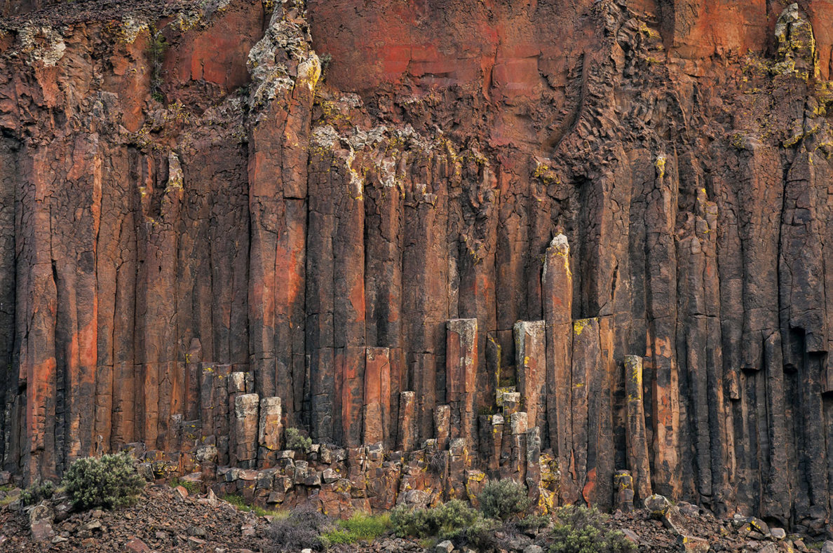
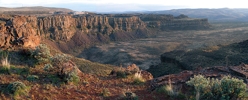
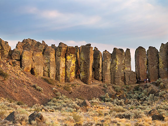
As recently as 10,000 years ago, in the waning days of the last Ice Age, as much as 500 cubic miles of water broke through an ice dam in western Montana and surged across the Columbia Plateau. Dozens of floods swept away topsoil and all but the most resolute and protected pieces of basalt. The floods’ handiwork is particularly striking at Frenchman Coulee, where the waters made a final plunge to the Columbia River, working around a rib of basalt into two alcoves.
The coulee sits just off Interstate 90 and Silica Road, the route to the Gorge Amphitheatre. A two-lane road follows the edge of its northern alcove, serving up an expansive view of a flat bench fringed by massive cliffs of stout and occasionally twisted basalt columns.
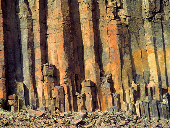
It is the roadcut of roadcuts, a frozen, crystalline reminder of a world overrun by molten rock, then rent by hydraulic forces bordering on the biblical.
“You’re looking at about a million years here,” says Reidel. Toward the top sits the Roza Member, the result of about five flows from just under 15 million years ago. Below that is the Wanapum basalt, which had some 68 flows between 15 and 15.6 million years ago. At the bottom, flat and defiant, sits the 15.6- to 16-million-year-old Grande Ronde, whose massive, 100-plus flows came so frequently that one might still be warm when the next arrived, letting material from one flow weld to the next.
“The Grand Ronde is like a set of bricks cemented together,” says Reidel.
Greater cataclysms may someday come this way, but in the battle of old basalts and young floods, the Grande Ronde won out.
“It must have been spectacular,” says Reidel. “Certainly a place you would not want to be.”
Web extra
Flood Basalts and Glacier Floods: Roadside Geology of Parts of Walla Walla, Franklin, and Columbia Counties, Washington (field trip guide)
Formed by Megafloods, This Place Fooled Scientists for Decades (National Geographic)