The archaeological excavation itself is hardly remarkable. It’s about a meter long by a half-meter wide and a meter deep. Nick Foit, a geologist, comments that it must have been pretty cramped to work in. Photographer Zach Mazur works his way around the hole, careful to step where archaeologist Bob Mierendorf tells him, shooting its cubic ordinariness from different angles.
“See this orange golf tee,” says Mierendorf. He’d pushed it into the floor of the pit to mark where he’d previously removed a tiny piece of charcoal. Carbon dating indicated the charcoal was the remnant of a cooking fire from 9,600 years ago.
With occupation dates in the Americas continually being pushed back further and further, as much as 30,000 years and beyond, a 9,600-year-old cooking hearth is not that remarkable in itself. But we are standing at Cascade Pass, 5,400 feet high, deep in some of the most rugged country in the United States.
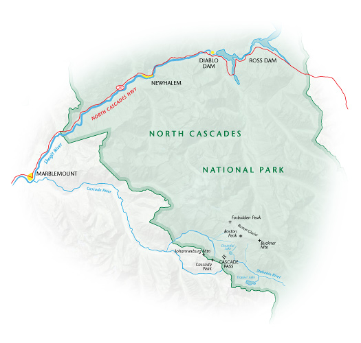
Cascade Pass easily makes the short list of the most beautiful places in the world. The pass is a saddle between drainages. The east side is the watershed of the Stehekin and Chelan Rivers, which flow to the Columbia. The west side is drained by the Cascade River, a tributary of the Skagit. Peaks around us range between 8,200 and 9,200 feet. Forbidden Peak. Mount Formidable. Johannesburg Mountain.
The landscape is indeed spectacular, even without the glaciers.
Across the road from the trailhead, at 3,000 feet, there’s a glacier. Nearly 80 percent of the glacier area in the conterminous United States is in Washington, and most of those glaciers are in the North Cascades, many of them visible from Cascade Pass. Seven hundred and fifty-six glaciers have been identified in the North Cascades, 318 of them within the Park.
Cascade Pass is one of the most popular hikes in North Cascades National Park, providing the quickest access to the high country of any hike in the Park. But today, we are alone. A bridge on the only road in was damaged by a flood last winter and is closed for repair. Earlier, Mierendorf had parked a Park Service van on this side of the bridge, and we’d walked across the damaged bridge from one vehicle to the other. Without a vehicle, it’s a 14-mile hike from the bridge to the trailhead. But when the bridge is open, the trail to Cascade Pass is heavily traveled, with obvious reason.
Not so obvious, however, is what people were doing up here 9,600 years ago.
Even though we’re still sweating from the four-mile hike to the pass, the September air is cooling rapidly. Black clouds mass ominously to the west, and the wind over the saddle is increasing. We are starting to accept that we are about to experience that overwhelming expression of Nature sometimes called the Sublime. A late summer storm in the North Cascades. “The late great Mierendorf Expedition,” jokes Foit.
Mierendorf has spent the last couple of decades trying to convince the archaeological establishment that pre-contact Northwest Indians did not confine themselves to the lowlands, but lived in the North Cascades and frequented the high country. When Mierendorf first started working at the park, Cascade Pass was one of 17 archaeological sites identified within it. Since then, he has identified nearly 300 more. Forty-five of those sites are located between 4,000 and 7,000 feet.
Obviously, population densities in the mountains were nowhere near what they were along the more hospitable coastal lowlands. Mierendorf argues simply that lower density does not mean absence. An earlier assumption by archaeologists was that Indians actually avoided the mountains, and any contact between coastal and interior tribes was accomplished by traveling along the Columbia Gorge. Mountains were a barrier, not a destination. The idea that prehistoric people crossed the Cascades on foot was simply incomprehensible.
Such an assumption is certainly understandable. The North Cascades is tough country. Even though only two volcanic peaks are higher than 10,000 feet, the deep glacier-carved valleys create dramatic local relief, often as much as 6,000 feet between valley floor and peak.
Alexander Ross, a fur trader with the North West Company, made the first non-Indian crossing of the North Cascades in 1814, from east to west, guided by an Indian. “A more difficult route to travel never fell to man’s lot,” wrote Ross.
So why was the question of the Indians’ presence in the mountains such a mystery? Why didn’t archaeologists just ask the Indians?
“What I found,” says Mierendorf, “is they did ask the Indians. But it was very scattered and piecemeal. Anthropologists who did ask the tribes were always focused on something else.”
For example, he says, the best ethnographic study of the North Cascades is June Collins’s Valley of the Spirits (University of Washington Press, 1974), conducted in the mid-20th century. The focus of the book is the spiritual life of the traditional Upper Skagit people. Collins did not venture into the backcountry. An ethnographer gathers what information she can about a culture from the stories and memories of her subjects, and at the time there were no longer any Indians living in the high country. But, says Mierendorf, she did record some information that indicates the upper Skagit people traditionally were better hunters and wore more skin clothing than their lowland, saltwater relatives. When they had excess meat, they would trade with saltwater relatives for things like dried clams.
A more basic reason for the lack of anthropological information on mountain Indians is that historically, anthropologists have tended to focus on larger, more obvious, populations.
“If you just drew a line around the Northwest Coast culture area, as it has been studied historically,” says Mierendorf, “well, it would extend a thousand miles long from southeast Alaska all the way to central California, and it would be a hundred yards wide.”
At the bottom of the excavation are flat stones next to the remains of a fire, seats for the people of 9,600 years ago. The landscape they gazed over was even more austere than the modern subalpine we’re amidst. Keep in mind that the land was still recovering from the last ice age.
Lacking the current layer of organic matter and ash of nine separate volcanic eruptions over the past 9,600 years, the landscape surrounding us was even more rocky, says Mierendorf. Since the soils had less organic matter, they’d have been lighter in color. More rock surface would have been exposed, and the rocks themselves, lacking the eons of lichen buildup, would have been lighter colored. The landscape surrounding us would have been very bright, he says.
It would seem that with such a severe landscape, there would have been little food to draw the early people up here.
On the contrary, there would have been, says Mierendorf. Although the landscape was more barren, the plant life would have been more clumped together in discrete islands. Those clumps each would have had their ecotones, or transitional zones, around them, supporting a diverse mix of plants.
There would have been edible bulbs, glacier lilies, spring beauties. And berries. Even now, as then, in late summer, the huckleberries are still thick.
Marmots were surely here at the time, barking at our predecessors the same as their descendants bark at us. Marmots were a great source of fat. “I mean, what would be better to eat than a big fat slow vegetarian?” says Mierendorf.
At one point, Mierendorf pulls a clump of hair off a bush. It is thick and soft. Indians have long hunted goats for their meat and their warm hair.
Even if food had not been plentiful here 9,600 years ago,
why else would people have been up here? Trade is one reason.
“Every archaeologist in the state would say they’re not surprised we found this site at Cascade Pass. Everyone knew it was a trade route.”
The only problem is Mierendorf has found no trade goods. Trade goods would have included obsidian, for tool-making, and shells.
“I’ve compiled long lists of trade items,” he says. “We haven’t got any of that.
“I’m not saying they weren’t trading all that time. But we can’t find trade items.”
One thing Mierendorf is certain the people were doing at Cascade Pass was making tools. Throughout the layers of the test pits are not only “debitage,” the remains of tool making, but partially-made tools, dead-ends, mistakes. “They were bringing tools with them from east and west of here and making tools right here.”
Between 8,600 and 4,000 years BP (before present), the materials used at the site were quartz crystal, jasper, and Hozomeen chert. These materials are predominantly local, says Mierendorf, indicating that use of the pass at the time was for access to the adjacent terrain. “The quartz crystal comes from right here, a quarry right over there,” says Mierendorf, pointing up the saddle to the northwest.
After 4,000 years BP, chert and chalcedony dominate, their out-of-area origin indicating that use of the pass was increasingly for travel across the mountains.
Overall, however, the presence of multiple hearths within the test pit do not indicate one-night sleepovers during a quick trip through the mountains.
“With continuous and recurrent visitation for 9,600 years, we’re beginning to get the picture, these people were going up to the mountains to be in the mountains.”
Perhaps the most profound reason that not more is known about Indian presence in the high country is that the local culture itself had forgot the details, due to the decimation of the native populations by introduced diseases. Historian Robert Boyd, in his The Coming of the Spirit of Pestilence: Introduced Infectious Diseases and Population Decline among Northwest Coast Indians, 1774-1874 (University of Washington Press, 1999), concludes that the total native population on the Northwest Coast fell within that century from about 184,000 to 37,153—an 80 percent decline.
Although populations above, say, Rockport were probably never large, those downriver were likely fairly sizeable. Regardless, whole villages undoubtedly simply disappeared. Survivors may have moved in with saltwater relatives. With such extraordinary social disturbance, cultural memory cannot survive intact. With no written record, it is impossible to estimate how much of their cultural history was forgotten.
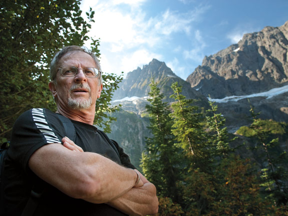
 Staff illustration—Cascade Pass in North Cascades National Park
Click on map for larger view (PDF)
Mierendorf’s experience in the North Cascades began in 1984. He was working on his doctorate at WSU and was a non-teaching research faculty member in the Center for Northwest Anthropology.
North Cascades National Park sent out a request for a proposal to do an overview and assessment study of archaeological knowledge of the tribes who had used the park.
Allan H. Smith compiled the ethnographic review, resulting in Ethnography of the North Cascades (Center for Northwest Anthropology, WSU, 1988). Smith started the anthropology program at WSU in 1950 by hiring Richard Daugherty. He also wrote the ethnographic review of the Mount Rainier area, later published by WSU Press as Takhoma: Enthnography of Mount Rainier National Park (2006), and was director of anthropology for the National Science Foundation.
Mierendorf took on the archaeological survey, beginning his immersion in the deep history of the area.
Before he began, only 17 archeological sites had been recorded in the park. He asked if he could record other sites that he ran across in his survey. Yes, but there wasn’t any money for that. After the survey was finished, the park found money to keep him working summers. He put everything in Pullman in storage and spent his summer living in his tent and exploring the park. Finally, in 1989 he became the first park-based archaeologist in the Pacific Northwest. And he kept exploring.
“Sites were everywhere,” he says.
He and his crews have since surveyed about 4 percent of the park, which totals 684,000 acres. Admittedly, he says, that 4 percent constitutes some of the highest-probability areas for finding sites.
Their surveys have revealed hunting and foraging camps and quarries for chert and obsidian.
The most significant discovery was Cascade Pass.
Cascade Pass is a highly unlikely archaeological site, says Foit, who worked with Mierendorf to date the site. “It’s the top of a ridge,” he says. “You’d think there’s no way there’s anything’s going to be preserved there.”
Mazur, the photographer, stops shooting briefly to ask the obvious question. How did anyone find a 96-century-old hearth on top of a windblown saddle?
Years before the initial archaeological survey of the pass in the 1970s, a visitor had found an arrowhead and turned it in to officials.
Based on that original discovery, the Cascade Pass site had been identified by an archaeological reconnaissance survey from Western Washington University in 1977. But it was not excavated until 2005, when Mierendorf and Foit examined it.
The difficulty of working in the Cascades, says Foit, is erosion. Any site on a slope or beneath one, for example, is likely to include sediments that have washed, slid, or blown from up the slope. But here at the Cascade Pass site —far enough from the eroding slope at each end of the saddle, what they found was an uninterrupted “meter of sediment representing 9,600 years.” The site can be interpreted literally by its layers. If they find a layer of Mazama tephra, or ash, it’s fairly certain that it remains where it fell after the volcano’s eruption.
Add to this advantage the cooking pit itself. It’s a human-created geologic receptacle, accumulating tephra layers in a very orderly fashion.
Before North Cascades National Park was founded by Congress in 1968, Cascade Pass had been a very popular horse camping and hiking destination. It had been loved to death, says Mierendorf. It was trampled and eroded, the ground compacted so the native vegetation could barely grow.
Under the mission of the park, the area was closed to camping and gradually restored to a relatively undisrupted condition. But then Mierendorf put a stop to the restoration.
Managers wanted to put boulders where crumbling benches had been. Mierendorf said no. He first wanted to know what might possibly lie beneath the surface.
Mierendorf’s smallest sampling device is a corer, a long concave tool, a pipe with part of its wall missing. He demonstrates around test pit #2, pushing it into the ground and pulling up a three-quarter inch core of soil, examining it for tephra layers—and charcoal.
“But my main discovery tool was a post hole digger,” he says. Recent re-design of the classic two-handled digger enabled him to dig deeper than with the original design. He and his crew used it to dig close to 40 different exploratory holes around the Cascade Pass site.
“We dig slowly, and whenever we see a soil color change we stop, screen everything up to that point, looking for artifacts, then looking at the soil, describing it, measuring the depth.”
The fire pit, test pit #1, was discovered with a post hole. It had artifacts, remnants of tool making, top to bottom.
Besides artifacts, of course, Mierendorf found ash layers. No surprise. What was a surprise, he says, is once they penetrated beyond the ash layers, there was
another set of artifacts. How old could it be?
He and Foit knew the site had to be at least 4,000 years old, as they identified the layer as an eruption of Mount St. Helens. And then they found a Mazama layer.
Mazama is the volcano that created Oregon’s Crater Lake, 7,600 years ago. Whereas the 1980 Mount St. Helens eruption spewed one-half cubic kilometer of ash, Mazama produced 34 cubic kilometers, spreading a thick, easily distinguishable chronological marker across the Pacific Northwest and beyond.
An archaeologist is necessarily skeptical. And so in spite of its apparent promise, Mierendorf suspected the Mazama layer had been re-deposited by wind, and so could not be relied on for dating.
So he opened up a test unit, a larger hole. Again, they found artifacts, then ash, more artifacts, then quartz crystals.
Mierendorf started getting excited. Maybe this was very old. And then they found charcoal. And from charcoal, they could extract carbon dates. They had reached a strata that was 8,800 years old.
They tried another test pit and uncovered cooking hearths. Eventually they uncovered evidence of more than 9,600 years of human use. Mierendorf suspects the site might be even older.
Evidently the pass was a popular gathering place over the centuries. Mierendorf found a quartz outcrop in the bedrock nearby, the source of the quartz crystals. So the site was a quarry, among other uses. The quartz revealed the use of microblade technology. Microblades were very sharp small blades flaked off quartz or other silica-rich stone. Microblade technology apparently originated in Siberia, perhaps as early as 35,000 years ago. The technology was known throughout British Columbia, Alaska, and into Siberia. At least six independent groups in North America, including Pacific Northwest peoples, used the technology. The microblades were hafted to shafts to make knives, drills, and barbed spears.
On the hike up, Foit and Mierendorf had taken a long jaunt into crystallography, weighing the virtues and tradeoffs of various tool-making materials, namely the local quartz crystals, chert from nearby quarries, and chalcedony, which is really a more specific form of chert. From a functional perspective, flint is a higher quality chert.
“I think they figured out pretty quickly, once you get a flake or a tool or a sharp edge out of a quartz crystal, it had to be much more durable,” says Mierendorf.
“It might not have had as sharp an edge,” says Foit, “but it lasted longer.”
“Why wouldn’t it be just as sharp?”
“I don’t know,” says Foit. “This is just a hunch, but when you have as tight a bond and you break something, it doesn’t break with as even a degree all along the edge. The sharpest is obsidian.”
“But that’s not a crystal,” says Mierendorf.
“Right, that’s my point. It has no directional bonds.”
“What was the question?” I ask.
“My real thought here,” says Mierendorf, “utilization of quartz crystal might provide tougher, more durable edged tools.”
“Quartz has a hardness of about seven,” says Foit. “Glass is 5.5 to 6. Chalcedony is about 6.” He refers to the Mohs scale mineral hardness. The scale is one through ten and is exponential. Talc is one. Diamond is 10.
The long and continuous use of Cascade Pass raises an interesting question, one that has brought Mierendorf, who represents the cultural resource perspective of the national park lands, into conflict with those who represent the dominant natural resource perspective. And that is the definition of wilderness.
William Bradford, leader of the Separatist colonists who sailed on the Mayflower in 1620 and later governor of Plymouth Colony, wrote in his journal of his response to his new home: “Besides what could they see but a hideous and desolate wilderness, full of wild beasts and wild men—and what multitudes there might be of them they know not…”
In spite of his bleak appreciation, Bradford makes, if unwittingly, an interesting point. He includes people in that wilderness.
Modern wilderness aficionados are not always so inclusive.
Wilderness did not exist until Congress created it in 1964, Mierendorf says, well aware of the hackles raised by such a statement. He sees wilderness as a policy definition rather than a state of wildness, as Bradford and others use the term.
“People argue that we should maintain land as it was when the colonists arrived,” says Mierendorf. “No. It was a traditional homeland of indigenous people. They were sovereign nations and held tenure to the land.”
“But they also modified the land,” adds Foit.
“The hardest thing for non-Indians to understand is that indigenous people were land managers.”
Mierendorf is unquestionably a supporter of wilderness. “The Wilderness Act is working,” he says. “But let’s not say something scientifically unsupportable to justify it.”
The idea of wilderness in many minds clearly belies human impact. The notion of pristine does not jibe with the realization that an area has been occupied and lived in for more than 10,000 years.
In 1916, popular mystery writer Mary Roberts Rinehart rode up to the pass with local horsemen from Lake Chelan, then wrote about it in a book called Tenting To-night: a Chronicle of Sports and Adventure in Glacier Park and the Cascade Mountains. The tameness of the title actually masks the difficulty of the trip. Her party came over the ridge between Cascade Pass and Doubtful Lake, a thousand feet above us. She writes of the horses that fell off the steep traverses and of taking a wrong path up from Doubtful Lake and “having a noiseless attack of hysterics.”
The photographer who accompanied Rinehart recorded a view of the pass, looking back up at the ridge over which lay Doubtful Lake. The photograph is striking. The pass is lush with grass, but there are far fewer trees than currently exist.
The assumption of many wilderness advocates had been that there had been more trees, in the belief the horsemen had sawed them up and burned them.
Wilderness is a deeply held value, says Mierendorf, and it quickly becomes emotional. Attacking the tenets of wilderness can equate to attacking one’s values.
“That’s not what I want to do,” he says. “I want to attack intellectual bias.”
The sublime storm we’d expected does not materialize, at least not the rain. But the wind is stiff, the clouds are still thick, the temperature has dropped 20 degrees, and we’ve put on all the extra clothes we’d brought. We start down. It will be warmer once we get in the trees out of the wind. A golden eagle soars above us on the wind flowing over the pass.
“I think it’s going to clear off,” says Mierendorf.
“Maybe in a week, somewhere,” Foit replies.
We watch long wisps of clouds flow through the saddle. Against a wall above us, one stream of cloud curls up and around in a spiral. Foit and Mierendorf study it, speculating about the wind patterns and the deposition of ash up here.
On the way down, someone finally addresses the subject of the bad smell I’d been noticing on and off. I thought for sure I had dog poop embedded in my hiking boot. Someone else thought it was very dirty socks. It’s valerian, one of the most important native medicinals, says Mierendorf. One of its uses is as a sedative. Nature’s Prozac, some call it. Earlier, we’d found false hellebore, a violently poisonous plant with many medicinal uses, if the user knows its secrets.
We’re surrounded, in fact, in this rich and timeless homeland, by plants native people used as food and medicinals. One can only guess how much knowledge, botanical and otherwise, has been learned and forgotten in the ten thousand years since the ancestors sat by their fire at Cascade Pass.
Determining a site’s age

One of geologist Nick Foit’s specialties is tephrochronology, the study of volcanic ash, or tephra, strata in soils. Every volcanic eruption has its own chemical fingerprint. Ash from an eruption can be spewed for thousands of miles, depending on the force of the eruption and the prevailing winds. The layers of ash near the volcano can be analyzed in relation to organic materials that were buried. The organic material can be dated through a process called radiocarbon dating, by which the amount of the isotope carbon-14 remaining in the material can be measured. Living things absorb the isotope while alive. As soon as they die, that absorption stops, and the isotope starts decaying. That rate of decay is known, and the resulting measurement results in an age in “carbon years,” which has been correlated with dendrochronology, the measurement of tree rings, and can be translated to calendar years.
Once the age of the ash layer is determined and identified, it can be used to determine the age of an archaeological deposit. Foit identifies the particular ash by analyzing its chemical content through a process called electron probe microanalysis, which requires a very sensitive, very expensive instrument that resides on the eighth floor of Webster Hall.
Web extras
Gallery :: Photos of the North Cascades by Zach Mazur