Financial hardship, fires, and spring floods: In 1890 the community of Pullman was in desperate need of some good news. A hungry blaze had leveled the city’s newly rebuilt commercial district only three years after it first burned to the ground in 1887.
Then on May 24, 1890 word got out that a “gusher” had been struck. Fifty gallons of water per minute rushed up to the surface where contractors had been drilling a well for the Palace Hotel. They had accidentally discovered an artesian source, a well under pressure that once tapped was forcing water up. It was the turning point for an early struggling Pullman.
The story of the American West has always been a story of water, how much of it there is and who controls it. So for a small agricultural town in eastern Washington, free-flowing groundwater was almost better than striking gold.
By 1891, according to a yellowed copy of the Pullman Herald, every home in Pullman had clean running water. Well-digging had become a town spectacle. Information pamphlets touting Pullman’s “ever-flowing springs of pure-abundant cold water” lured potential residents to the area. The discovery of artesian water had great impact on the future of Pullman and the arrival of Washington State College.
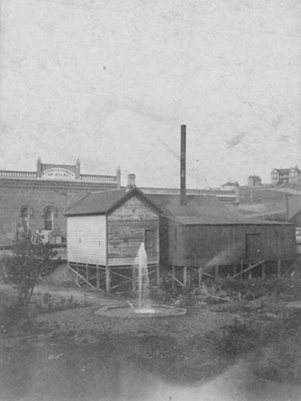
Bob Luedeking, a retired WSU chemical engineering professor and member of the Whitman County Historical Society, says if it weren’t for the wells, the school might be somewhere else entirely. “I think [the wells] played a critical role in the decision of the location committee,” he says, pointing to an 1890 photo of three men smiling in front of a gushing fountain. The men were members of a state-appointed committee to find a suitable site for Washington’s new State Agricultural College.
Pullman used its artesian wells for nearly 80 years. At one time the city had more than 14 capped wells continuously funneling water to homes and businesses. One businessman used the water to power the equipment in his butcher shop. There was even an Artesian Hotel in town.
But in the 1950s the wells started running out. By the 1970s only a few artesian-powered drinking fountains remained in what was once the “Artesian City.”
Luedeking remembers stopping for a drink at an artesian fountain while walking home from campus in the late ’60s. “The big fountains had disappeared long before I came [in 1956],” he added. All that remains today is a replica of the ones that capped the wells that helped put Pullman on the map.
Back then, the townspeople didn’t know how much water they had or how long it would last. Fortunately, when the artesian wells ran out, Pullman found a good water supply by tapping deeper, drawing water from aquifers buried deep below the surface.
Beneath hundreds of feet of prehistoric rock lies a volcanic reservoir so vast the experts have yet to determine its boundaries. Its 10,000-year-old water is considered pristine and, some say, unrivaled in taste.
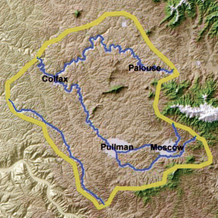
The Palouse River Watershed, which includes Pullman and Moscow, Idaho (eight miles to the east), is one of the largest watersheds in Washington. It includes two aquifers: the smaller, shallower Wanapum and the deeper Grande Ronde which supplies most of the water to the more than 56,000 residents in the Palouse area.
On a typical spring day, the 700-horsepower pump on well No. 8 whines like a jet engine as it funnels thousands of gallons of water each minute through a 12-inch-wide pipe and out into the WSU water supply on the Pullman campus. No. 8 was drilled in 2003 after water levels had dropped too low for half of the campus’s wells to reach.
Despite dozens of studies, scientists haven’t been able to establish just how much water is in the Grande Ronde, which now supplies around 90 percent of the water to the Palouse basin and at the same time seems to be dropping each year.
In contrast to the declining Grande Ronde, the Wanapum is now recovering after water levels and water quality dropped dramatically in the 1950s and early 1960s when it was the region’s main water source.
Ours is just one of a growing number of uncertain or diminishing aquifers across the United States. Aquifer water levels in Texas, Oklahoma, and Kansas have dropped by nearly 100 feet in some areas due to growing populations and heavy irrigation of farmland, according to the United States Geological Survey. Development in south-central Arizona, near Tucson and Phoenix, has caused aquifer declines ranging from 300 feet to 500 feet. Long-term pumping since the late 1800s is linked to a 900-foot decline in the Great Lakes watershed, the sole drinking water source for 8.5 million people in the Chicago-Milwaukee region.
Here in the Palouse, the community is learning a lesson from early Pullman, hoping to quantify and figure out what to do about the water supply before it gets too low.
The Palouse Basin Aquifer Committee is an inter-agency technical advisory group formed in the early 1990s after several years of data showed that the Grande Ronde Aquifer was dropping at least one-to-two feet per year. The committee is composed of delegates from the four major users of water in the Palouse, the city of Moscow, the University of Idaho, the city of Pullman, and Washington State University and from the city of Colfax, Whitman County, and Latah County.
Its purpose is to balance water use and supply to the Palouse, says Robert Corcoran, PBAC board member and executive director of WSU Facility Operations. “PBAC is unique in that it is a regionally managed basin,” Corcoran says. “It is inter-state, inter-city, and inter-university.”
In 1992 PBAC started a Ground Water Management Plan, which reduced overall pumping levels across the Palouse. The first year 3.09 billion gallons of water were pumped; by 2006 that number had dropped eight percent to 2.83 billion gallons.
PBAC has contracted with numerous specialists and scientists to study the aquifer. The group’s support has led to a number of completed and ongoing research projects that may help address the aquifer’s decline. Their work includes monitoring water levels, determining interconnectivity of the aquifers, and detecting thickness and permeability of area soil and rock formations. At the heart of this research is an underlying need to get a centralized perspective of the aquifer, in size, shape, and flow patterns.
WSU hydrogeologist Joan Wu has spent years studying area aquifers and how they may be connected. With graduate student Farida Leek ’06 she collected and compiled data on the aquifers to form hydrogeological maps, the first large-scale consolidation of well data for the area. They found evidence showing that there is virtually no change in overall geological elevation across the basin, meaning the chances of water levels declining because of a natural discharge are slight because there is no major slope where water could drain, says Wu. This means that artificial pumping is mostly to blame for the decline.
Their studies also show that vertical water collection in the Grande Ronde from surface water runoff is nearly nonexistent. Layers of basalt and compacted sediment prevent water from percolating through the ground and refilling the aquifer, meaning “recharge from precipitation is very limited,” Wu said.
Other studies by retired UI geologist John Bush suggest the possibility of “lateral recharge,” by which groundwater enters the aquifer from the side instead of the top by flowing through sediment layers off of Moscow Mountain.
Even though PBAC continues to fund important research, some critics say the committee should be doing more to characterize the structure and behavior of the Grande Ronde.
And it would help to know how well the aquifer is connected, said WSU hydrogeochemist Kent Keller. The solution? More test wells, he says. “You don’t want to do anything more until you can monitor the effects of what you do.”
Creative, and sometimes costly, solutions to the aquifer’s decline have been kicked around for years and were again brought up
at the 2007 Palouse Basin Water Summit held a year ago in Pullman. They include storing water from peak winter runoff or even diverting water from the North Fork Palouse River.
WSU has presented the Legislature a request for a waste-water reclamation project, which will be resubmitted for $16 million, to provide the University and Pullman 1.3 million gallons per day of treated effluent. Also, according to WSU Facilities Operations, intensive water-saving efforts have decreased consumption on the Pullman campus by 31 percent over the last two decades.
Alternatives like these need to be considered if water levels keep dropping, Corcoran says. “Conservation alone won’t get you there.”
PBAC’s overall timetable for action is to have a plan to sustain or replenish the aquifer in place by 2010, and by 2020 to initiate a sustainable plan of action, says Corcoran.
Web exclusive
Gallery: Postcards and photos from Pullman’s artesian wells of the past