A step in the race to save Puget Sound
Kiket Island has two miles of shoreline, an upland forest with old-growth characteristics, and an untrammeled wildflower prairie.
The 84-acre treasure surfaces in the northern part of Puget Sound. Here, two hours north of Seattle, tidal currents pour through Deception Pass into Skagit Bay on the west side of the Swinomish Indian Reservation.
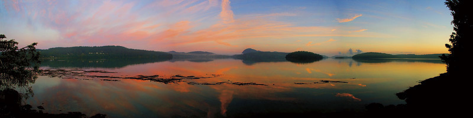 Photo Rob Nevitt
This quiet parcel, which has hardly been touched since the region was settled in the 1850s, is a vital piece of a statewide endeavor to restore Puget Sound to health by 2020.
For such a quiet place, it has seen a lot of action. It was once slated to hold a nuclear plant for the City of Seattle, and for a few months this year it took the limelight as a band of interested parties, including the state, the Trust for Public Land, and the Swinomish Tribe, hammered out a $14 million deal to keep the island from being sold to a developer and to join it to the Deception Pass State Park, with the tribe listed as co-owner.
The careful and sometimes controversial deal was made to protect the island and 12 adjacent acres on the mainland, which includes a pocket estuary where juvenile salmon migrating out of the Skagit River might feed and prepare for their long trip into the ocean.
The deal almost didn’t happen.
We manage to get a rare view of the place just a few weeks after its sale in June. Driving beneath a green canopy of trees on Snee Oosh Road we arrive at a locked chain-link gate at the top of a single lane drive. From here it is impossible to tell if this is the way to the island, or just another long drive to one of the beach houses along the shore.
Steve Hinton ’84, a restoration ecologist with the Skagit River System Cooperative for the Sauk-Suiattle and Swinomish Indian Tribes, is the next to arrive. A few minutes later Todd Mitchell, ’97 MS, the Swinomish Tribe’s water resources manager, pulls up with the key so we can wander in and see for ourselves the old-growth trees, the untouched beaches, and the vacant home that was built on the southwest end in the 1950s.
Mitchell’s dad and others in the Swinomish community remember visiting the island years ago. One of its previous owners, Gene Dunlap, welcomed people to use the open beaches on its south side. “The gate was always open,” says Mitchell. But that hospitality ended in the summer of 1969 when Seattle City Light bought the island and started plans to build a $250 million nuclear power complex there and 10 miles to the north on Samish Island. Engineers believed they could cool the reactor with the tidal currents. But after numerous studies and many heated community protests, the city scrapped the idea. Since 1982, the property has belonged to a Bellevue-area family.
To Mitchell, the recent change in ownership of Kiket means the return of a cultural and historical resource to the Swinomish. The Indians harvested shellfish from the tidelands and salmon from the shores. The deal also reinforces treaty rights to the tidelands and ensures the tribe has a hand in maintaining a precious and wild place within the boundaries of the reservation.
Hinton, who is working on a doctoral degree in natural resource management at WSU, says he also sees promise in the deal. He’s interested in the beach landscape on the south side, which faces the Skagit River Delta, and around the island to the lagoon just north of where a gravel tombolo links Kiket to the mainland. We stop to look at the lagoon as a heron glides over. Here chinook salmon fry that have made their way down the Skagit River can find a safe haven where fresh seep springs blend with the salty Sound. The juvenile salmon can feed and mature before heading west through Deception Pass and out to sea. “The more they can hang in here, the better off they are in the long run,” says Hinton.
Our group crosses the gravel drive and we hike up the single road that runs the length of Kiket. As we reach the western point, the two men are much less interested in the home site—a tennis court, which had been overgrown with weeds, or the small salt water swimming pool—than they are in the wilderness.
We continue on to the “bald,” a second tiny island off the end of Kiket called Flagstaff Island. We stop at the edge of the prairie, which looks much as it did when the first explorers sailed into the bay. We look across the water to Deception Pass and the 180-foot-high bridge that spans it. And then turn our gazes south along Whidbey Island and across Skagit Bay to another stunning view: Lone Tree Point, a landmark on the reservation.
Kiket Island is a place to preserve and restore chinook habitat, says Hinton. It’s a continuation of his work along the Skagit River Basin, the Sound’s largest tributary. The Skagit has many things going for it as far as providing habitat for salmon, he says. A lot of land upriver in the mountains was long ago placed under federal protection. Then the spotted owl wars took more ground out of development in the 1980s. And the best news is that the upper Skagit wasn’t really humanized until the 1970s when the Cascade Highway was punched through, says Hinton. “Before then, those roads were practically wagon trails.”
But things get dicier for the salmon as the river nears the salt water. Over the past century the lower Skagit has been diked and developed. As the river spills to the Sound, much of the shoreline has been altered. Kiket, by contrast, is a rare stronghold for the fish. It has healthy eelgrass beds in a sound where eelgrass is disappearing. It has a spawning beach for forage fish like smelt and herring. And it is an important link in a chain of pocket estuaries that provide rearing areas for young salmon, says Hinton.
Overall, Puget Sound is losing more habitat than is being restored, says Hinton. Protecting places like Kiket prevents the hemorrhaging of undeveloped lands. Hinton himself is coordinating several projects to restore habitat around the Skagit River, along Skagit Bay, and up into the Swinomish Reservation.
To date, one-third of the Sound’s shoreline has been altered by hard structures like bulkheads and retaining walls, nearly three-quarters of the state’s intertidal salt marshes have been covered over with development and industry, and as the region’s population increases, so will the pressures on the Sound.
The biggest threats are toxic sites, stormwater, and loss of shoreline and habitat. The big push to restore the Sound to health by 2020 involves state, tribal, and local governments working with communities and conservation groups. And in the middle of that enormous project sit pristine places like Kiket. “You want to work in places where you have the largest core intact,” says Hinton, adding a mantra in ecology: “Protect the best, restore the rest.”
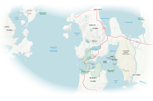
Map of Kiket Island (click on image for larger PDF)
There’s something in the water
Puget Sound as we know it didn’t exist 13,000 years ago. During the last great continental glaciations a giant ice sheet covered and killed the living landscape. But as the ice melted, the Sound came to life. It has become a universe in motion—birds, algae, fish, seals, whales, rivers, forests, undersea gardens, all part of a system that has been studied, mapped, and recorded. It is encased in mountains, washed out by tides, and constantly fed by a flow of rivers bringing rain and snowmelt down from the mountains. It’s a rich, complicated, stunning system.
Only recently has a new force begun to alter the water body. “A human invasion now rolls over the land,” notes Arthur Kruckeberg in his The Natural History of Puget Sound Country. Even in 1991, when botanist Kruckeberg first published his book, water quality was a major concern. The primeval forest was all but gone. “The crowning insult has been the progressive deterioration of water purity in that inland maritime jewel of our region,” he wrote.
In some ways the worst is over. Thanks to work started by the Environmental Protection Agency and local efforts, we are no longer burning garbage or dumping our sewage straight into the Sound. And we’ve closed down the worst polluting plants and foundries.
But when one problem goes, a variety of fresh ones can surface. One week before our trip to Kiket, scientists with the National Oceanic and Atmospheric Administration and the University of Washington warned of a rising acidity in the Sound, noting that in some places it was at levels lethal to shellfish and damaging fish eggs and oyster larvae.
The acidity has to do with increased acidification in the ocean, a probable result of global climate change, but that’s just one issue within the Sound, says John Stark, an ecotoxicologist and director of the WSU research station in Puyallup. Stark also runs WSU’s salmon toxicology research laboratory and is on the science panel of the Puget Sound Partnership, a state agency focused on the legislative mandate to clean up Puget Sound by 2020. His focus is on the effects of certain chemicals on freshwater and marine organisms.
In some parts of the Sound leaky septic tanks and runoff from residential areas are compounding the problem, he says. Detergents, adjuvants (drugs used to enhance the effects of other drugs), and surfactants (compounds that lower the surface tension of a liquid and are found in paints, detergents, and cosmetics) can harm aquatic organisms. These things are coating gills and trachea of organisms so there’s less oxygen exchange, he says, adding that some of the surfactants act as estrogen and there’s some evidence of feminization in male fish and sterilization in females.
Fourteen million pounds of toxic pollution washes into Puget Sound each year, according to the state Department of Ecology. That includes oil and grease from parking lots, fertilizers and pesticides from yards and farms, and heavy metals from vehicles.
Some chemicals, such as some pesticides, can break down and dilute rapidly. But others, like PCBs (found in old appliances and fluorescent fixtures) and heavy metals, hang around for a very long time. And some we don’t even realize we’re putting into the Sound, says Stark. Citing recent research, he points to birth control pills (which cause higher levels of estrogen through urine), caffeine, household products, and a pharmacy-full of items, including Prozac, ibuprofen, and sunscreen.
Stark isn’t simply interested in what one chemical can do. He’s focused on how they mix, how they change. “Animals in the environment are not exposed to one chemical at a time,” he says. “They’re often exposed to mixtures of a lot of different chemicals, but usually at very low concentrations.”
When certain things mix, though, you have synergisms. The result is more potent than expected. The compounds cause serious damage. Among the classic compounds Stark has been studying are organophosphates like diazinon and malathion, and carbamates like Sevin or other carbaryl insecticides. “If you expose fish to really low concentrations of these singly, you don’t see much of an effect on anything,” he says. “But if you have some of these mixtures together, especially with malathion, the fish start to die.”
“Mixture toxicity is very complicated,” says Stark. It’s hard for regulatory agencies like the Environmental Protection Agency to assess and predict what might happen. But it is something they’re working on, he adds.
While pesticide issues do come out of farmland, Stark is quick to point out that pollution from urban and suburban areas cause as many if not more problems. He cites a 2006 U.S. Geological Survey study, Pesticides in the Nation’s Streams and Groundwater, which looked at nearly 180 rivers and streams nationwide. The study found that many of the pesticides Stark studies were found in greater concentration in urban streams than agricultural streams. People need to apply their pesticides and fertilizers correctly, says Stark. What’s happening is they’re using them more frequently than allowed and in places where they’re not supposed to. “They need to be sure it’s not overshooting the lawn and landing on the sidewalk,” he says. From there it can wash right into a nearby stream or storm drain.
Turning the tide
Puget Sound, at 42,791 square kilometers, is the nation’s second largest estuary. When it comes to major waterways, it should be up there in the national consciousness with Chesapeake Bay, the Great Lakes, and the Everglades, says David Dicks, executive director of the Puget Sound Partnership. But right now the Sound is at the “kids’ table” with 27 others in the Environmental Protection Agency’s national estuary program. There, its peers include the Tillamook estuaries in Oregon (1,400 square kilometers) and California’s Moro Bay (240 square kilometers).
“Puget Sound has never really fit in that group,” says Dicks. And where federal funding has in the past come through for endangered species salmon projects, now many in Washington, D.C., are “salmon-weary,” he says. Yes, endangered species are at the heart of it, but there’s much more to it, he says.
In 2008, Washington Senator Maria Cantwell introduced the Puget Sound Recovery Act, which would amend the federal Clean Water Act to include Puget Sound and establish a federal Puget Sound program office. This would make the Sound eligible for as much federal money as the Great Lakes and Chesapeake Bay get in a year. If it succeeds, it will “create a sort of Yin to the Chesapeake’s Yang,” says Dicks. The Chesapeake, because it has so many states and borders involved, has to be a federally led program. “Here it’s the opposite,” he says. “We’re one state (and Canada).” The constituents are a diverse group (with advisors that include tribes, city and county leaders, businesses, and environmental organizations) that can provide a unified effort, says Dicks.
William Ruckelshaus served as the first chief of the EPA when President Nixon established the agency in 1970. He was also President Clinton’s envoy to the Pacific Salmon Treaty and President George W. Bush’s appointee to the U.S. Commission on Ocean Policy. Until this summer, he was chair of the leadership council for the Puget Sound Partnership. And he’s head of the advisory committee for the William D. Ruckelshaus Center, a joint effort between Washington State University and the University of Washington to serve as a neutral resource for collaborative problem solving within the region.
He has a long-range view of how Americans have been treating their waters. “We have as a society over a period of forty years brought point-source pollution under control,” he says, “Where we have not been successful is talking about non-point source pollution. We didn’t even discuss urban and farming and suburban runoff.”
Ruckelshaus recently attended a meeting of the Puget Sound Partnership’s Ecosystem Coordination Board at WSU’s Mount Vernon research station. The topic turned to retrofitting the region’s urban roads and rooftops to hold back contaminated stormwater from the Sound. “There is truth to the adage we’re paving Puget Sound,” says Dan Wrye, water quality manager for Pierce County. “We need to get a handle on how to at least pause it.” There are so many parties—tribes, cities, businesses, and citizens—involved, and not all of them want to spend the time and money to clean up the Sound, or see the need for
the expense.
Ruckelshaus sees a solution: a collaborative push. “The only thing that I’ve seen that works is to get the people affected at the table. We’ve got to figure a way to get people to believe it is in their interest to change their behaviors.”
A Sea change
We get a second view of Kiket with Jack Hartt, a ranger with Deception Pass State Park, as he motors photographer Ingrid Barrentine and me across Skagit Bay in a boat. The deal to buy the island had been years in the making, says Hartt, adding that he feared many times it would run aground. There were issues about what rights and duties the tribe would share, concerns about raising the money, and some public frustration about using state money to add to the park when the state is laying off workers.
Hartt is quick to point out that the $2.5 million in state park funds for the purchase came from accounts dedicated for land acquisition. Millions more came from other sources, including the U.S. Fish and Wildlife Service, the National Oceanic and Atmospheric Administration, and the state Salmon Recovery Funding Board.
The deal started simply. The owners approached Washington State Parks with an offer to sell the island. “We looked at it and thought, well, what a beautiful place,” says Hartt.
Hartt, who already had a taste for Washington’s spectacular landscapes from his seven years at Deception Pass State Park and before that at Riverside State Park in Spokane, was nonetheless amazed when he stepped foot on Kiket. “It’s one of those feelings,” he says. “Every new vista you saw was exhilarating.”
The tidelands are pretty much intact. And the upland forest reaches right down to the water’s edge, which is rare, says Hartt. Usually that area is developed with houses, cabins, and grassy yards. “Here we have two miles of shoreline where the trees are still hanging over the beaches,” he says. There’s forest, beach, owls, and eagles. It was enchanting, he says of that first tour. “I haven’t lost that feeling.”
The island fits in beautifully with the other protected areas of the park, he says, as we cruise by Strawberry and Ben Ure islands. The state parks system includes hundreds of miles of beaches and tidelands. These parks not only preserve nature and habitat, they offer a place for Washingtonians to connect to the Sound, be charmed by its beauty, and maybe learn to be better stewards of this resource, says Hartt.
Kiket was first owned by the Swinomish Tribe under the 1855 Treaty of Point Elliott. Like a number of other waterfront parcels in the area, the land was sold. In the 1950s, Gene Dunlap, owner of a tugboat business in La Conner, decided to move there with his family. Margie (Dunlap) Zimmerman x’53, lived there for a few years. “It was a beautiful place,” she says, recalling the beaches, the forest, and the serenity of the site. Her father Gene filled the home with souvenirs from overseas and loved to entertain.
Perhaps he would be pleased that the property now belongs to the park and will be open to the people of Washington, says Hartt upon hearing this.
When Seattle City Light bought the island for a nuclear power plant, the project triggered dozens of biology and ecology studies both on land and in the water, making Kiket one of the most studied areas of the Sound. It also triggered a tide of public protest over the safety of those who lived nearby and the damage it might do to wildlife. The utility scrapped the project in 1972.
In 1982, Seattle-area financier Wallace E. Opdycke bought the property for $1.4 million. As Hartt’s boat glides into the glassy bay on the northwest end of the island, he talks about how Deception Pass is perhaps the best all-around park in the state. Kiket, which will be available for day use only and only accessible by non-motorized boat, fits in well. “The park has the greatest variety of natural resources and recreational resources,” he says. There’s a large lake, the 1938 bridge behind us, and now ten islands all around us, bays and wetlands, hiking trails and history.
It even has its own legend—one that’s all about the health of the fish and the water. Back on dry land, we stop at the north end of the park to visit a woodcarving titled “The Maiden of Deception Pass.” The work is in honor of Samish Indian culture and a historic village nearby. The story is of a woman of the village named Ko-Kwal-alwoot who was lured into the Sound by a young chief of the sea. He came out of the water and asked her father if they could marry. But her family refused him.
Then the fish became scarce, the shellfish disappeared, and the fresh water dried up. Ko-Kwal-alwoot went to the water’s edge and begged the chief to bring back the food. He said he would, but only if her people would give her up.
The story resonates with us. As author/biologist Kruckeberg urges, we will have to change our behaviors and expectations for the sake of the Sound, to restore the fish and the shellfish.
Ko-Kwal-alwoot’s people worked out an agreement. She could marry the chief, but would return to the land each year to visit. Every year for four years the woman walked out of the sea. Each time she was colder and more a creature of the water than of the land. Barnacles grew on her face, kelp tangled in her hair, and by the fourth year she was obviously unhappy to be away from her watery home. Finally, her family decided to release her. While they never saw her again, they knew she would always be watching over the village, and they continued to enjoy the bounty of the beach and the fish of the Sound.
Web exclusives
Gallery: Photographs of Kiket Island (by Ingrid Barrentine)
Slideshow: Kiket Island: A concise history
On the web
Deception Pass State Park (Wikipedia)