A cartographer’s quest to re-create the Lewis and Clark Trail
When Meriwether Lewis and William Clark stood at the top of Lemhi Pass looking west in August 1805, they realized they had failed to locate the easy water passage from St. Louis to the Pacific Ocean that President Thomas Jefferson had dispatched them to find.
Instead of the easy, half-day portage between the headwaters of the Missouri and Columbia rivers that legend presumed, the captains of discovery and their team spent weeks struggling across the Bitterroot Mountains along the Idaho-Montana border, nearly starving before they finally stumbled into the Nez Perce Indians and the Pacific Northwest’s ample salmon runs.
Industry and ingenuity overcame these mountainous obstacles, creating a technological Northwest Passage of railroads, automobile roads, logging roads, and water roads—with a system of dams and navigation locks—that brought significant commerce and change to this vast territory in little more than a century.
These changes are significant as America sets out to rediscover Lewis and Clark on the 200th anniversary of their historic expedition. Nearly two-thirds of the Lewis and Clark Trail is under man-made reservoirs, says author and historian Martin Plamondon II. Another one-quarter is buried under subdivisions, streets, parks, banks, and other modern amenities in places like Kansas City, Fort Leavenworth, and Council Bluffs. Almost none of the original landscape is intact. No one appreciates this contrast like Plamondon.
His effort to retrace the expedition’s 7,400-mile journey has been so thorough and painstaking it has required 30 years. In some respects, Plamondon’s exploration has been as arduous as that of the Corps of Discovery. He hates camping. He suffers from a trio of congenital heart defects that make it impossible for him to hold a regular job, breathing problems from on-the-job exposure to anhydrous ammonia, and digestive difficulties that have robbed his frame of 100 pounds in the last year.
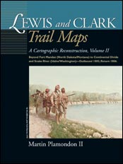
Yet, Plamondon has reconstructed the intrepid explorers’ routes, down to the last river bend, tortuous portage, and mountain trail, creating 530 hand-drawn maps that document the expedition in a way that will never be matched. The result, published by Washington State University Press, includes selected modern landmarks—to make it easier for readers to relate to the maps—and selected quotes from the expedition journals, all of which add up to a three-volume historical atlas and travelogue that also is backdrop for showing how dramatically the hand of man has transformed what seemed an endless wilderness to Lewis and Clark.
“No one has attempted this on a trail-wide scale,” says David Nicandri, executive director of the Washington State Historical Society. “You needed to be a cartographer, an astute analyst of the Lewis and Clark journals, and have a considerable amount of endurance. Martin is the sole qualifier.”
A Novel Approach
Plamondon, once chief cartographer for Clark County, Washington, set out to write a Roots-scale novel about each of the Native American tribes in the West—not redraw the landscape.
“I always liked history,” says Plamondon, who lives in a book-packed house in Vancouver, Washington, not far from where he was born 58 years ago. “I always liked American Indians. I wanted to write the truth about them, to set straight the misperceptions that whites have perpetuated for years.”
When a rainstorm ruined plans to take his daughters to the beach 30 years ago, he took them to Fort Clatsop, Oregon—where the expedition wintered in 1805—as a consolation prize. There his insatiable attraction to books drew him to an eight-volume set of the expedition’s journals. Suddenly, writing a book about Lewis and Clark seemed the perfect way to introduce his planned series on the tribes.
Plamondon figured it would take three and a half years to write his Lewis and Clark book. It took 27. He felt it necessary to learn about casting rifle balls, skinning buffalo with stone knives, starting fires with flint and steel, and other frontier skills for the sake of authenticity. And it sent him chasing another obsession. Maps.
As he researched his epic, as-yet-unpublished Lewis and Clark novel, questions kept arising about where things happened. Simple enough. Except that he soon found people didn’t agree on where things happened.
The only solution for a man of Plamondon’s talents and training: draw your own maps. And he had other incentives. His expertise in all things related to the expedition landed him on the governors’ Lewis and Clark commissions in both Washington and Oregon. That work added impetus to nagging questions: How can people appreciate the route Lewis and Clark followed considering the significant differences in the landscape today? How can one preserve such a historic trail considering all of the changes?
“I had to map it,” Plamondon concluded. “It’s the only way to preserve it.”
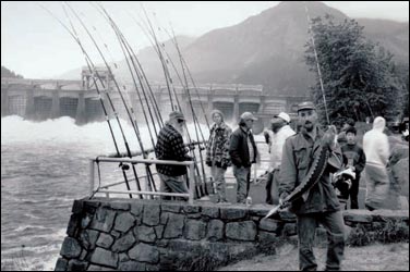
Because of all of the modern differences in the landscape, anyone who set out with Lewis and Clark’s original map today “in many cases would be confounded,” says Nicandri of the state historical society. “This is particularly true for the Snake and Columbia river segments [on Washington’s southern border] because this is the most dramatically changed landscape of the Lewis and Clark Trail, with the possible exception of the lower Missouri.”
Endless Mountains
“From this mountain I could observe high ruged mountains in every direction as far as I could see . . . began to Snow about 3 hours before Day and continued all day . . . I have been wet and as cold in every part as I ever was in my life, indeed I was at one time fearfull my feet would freeze in the thin Mockirsons which I wore, after a Short Delay in the middle of the Day, I took one man and proceeded on as fast as I could about 6 miles to a Small branch passing to the right, halted and built fires for the party agains[t] their arrival which was at Dusk, verry cold and much fatigued,” —William Clark, September 15-16, 1805, Bitterroot Mountains, present-day Idaho
By the time the Lewis and Clark expedition crossed into Idaho the fall of 1805, they had left the United States and were traveling in foreign territory. That fact seems to have occupied little of their attention. The expedition, whose food stocks primarily consisted of dried beans-and-vegetable soup, barely survived slogging and sliding across steep, timber-choked slopes of the Bitterroots in the relentless deluge of early-fall snowstorms.
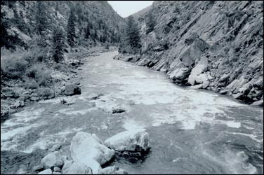
Today, maps show U.S. Highway 12 snaking along part of the explorers’ trail. Yet, this region contains the stretch of their route that has changed the least.
“From the front step at Monticello, across America to the Pacific Ocean, there remains one small piece of the Lewis and Clark Trail still as wild today as it was then—the land between Lolo Pass, Montana, and Weippe Meadows in northern Idaho,” says John Osborn, senior physician at the Spokane Veterans Medical Center and a passionate student of the explorers, who convinced the Sierra Club to undertake a national campaign to protect remnants of Lewis and Clark’s route, including sites in Idaho and Washington.
“This last section of the wilderness trail is a place of beauty, abundant in fish and wildlife, and a priceless heirloom of our American heritage, “Osborn says. “From Indian Post Office, it is still possible to scan these rugged Bitterroot forests and not see a single clear-cut.”
Indeed, the landscape is so compelling that writer Bernard DeVoto edited his Journals of Lewis and Clark in a cedar grove alongside the Lochsa River in 1953. His ashes were spread here two years later. Today, the towering cathedral of trees is memorialized as the DeVoto Grove.
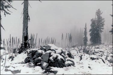
Yet, even this rare landscape is changed. For example, fur trappers followed Lewis and Clark by just 10 years and within a generation effectively eliminated several fur-bearing animals, WSU history professor Paul Hirt says. Aggressive efforts to eliminate large carnivores such as wolves and grizzly bears also changed the mix of wildlife species. A century of fire suppression has changed the way the forests look and, to a certain extent, the kinds of trees growing there. There are paved roads, well-marked trails, maps, and global positioning systems, all to guide the modern traveler through this area.
A Crude Beginning
William Clark was a gifted and under-appreciated frontier surveyor who surveyed most of Kentucky and Tennessee, Plamondon says. And legend has it that he delivered a survey of the lands the Corps of Discovery traversed that was accurate to within a matter of miles.
The latter claim is folklore.
Lewis and Clark hit the trail with only the most basic surveying tools: a sextant and octant for use in calculating longitude and latitude and several large compasses. They would have had to clear thousands of miles of trees, brush, and other obstacles in order to have clear lines to take sightings and accurately measure distances, Plamondon explains. Instead they often ended up using their best guess—also known as dead reckoning.
“They didn’t have the man power, and they didn’t have the money to do it right,” he says. So if you take Clark’s survey literally, it’s way off.
“If you draw out his traverse, you damn near end up in Hawaii,” Plamondon says. “He was 1,116 miles too long.”
Plamondon collected every bit of Clark’s data he could find, along with aerial photos, river navigation maps, atlases, roadside geology books, and other sources. He surveyed parts of the trail himself and recalculated Clark’s survey to correct for errors. He laid a rotating line of U.S. Geological Survey maps the length of his garage and, section by section, remapped the route of the Corps of Discovery, adding contour lines, rivers, some of the highways, and other modern landmarks. All of it by hand.
How many miles of line has he drawn?
“I wonder,” he responds.
His 530 maps required a total of 506,880 inches of borders alone, the equivalent of eight miles.
The result is so highly regarded that the Lewis and Clark Trail Heritage Foundation, headquartered in Great Falls, Montana, wants his original 18-inch by 24-inch maps. For now, they will be housed at WSU for greater ease in printing Plamondon’s atlases.
Scholars will clamor to study Plamondon’s larger maps, because they will have greater detail, says Nicandri. “This is where the long-term dividend for the work will be secured.”
Example Maps
Two examples from Martin Plamondon’s Lewis and Clark Trail Maps (WSU Press):
At the Indian Post Office on the Lolo Trail, Bitterroot Mountains, Idaho
At the Columbia and Lewis’s (Snake) River confluence
Ken Olsen is a journalist with the Vancouver Columbian. He spent this past year as an Alicia Patterson Journalism Fellow, examining the hidden world of public land swaps.
Here are contemporary photographs of the Lewis and Clark Trail by Greg MacGregor from his book, Lewis and Clark Revisited: A Photographer’s Trail…