Orest Pilskalns had electronic mapping on his mind long before coming to Washington State University, but it wasn’t until he was teaching a senior-level software engineering class the spring of 2006 that he knew he could realize his vision.
The assistant professor knew his students at WSU Vancouver had the skills and interest to tap into publicly-available map technology and adapt it for a wide variety of public uses.
“This is where you take the knowledge you’ve gained in other classes and apply it to a real-world problem,” says Pilskalns, who earned his doctorate in computer science at WSU in 2004. “We had a really talented group.”
Pilskalns started imagining commercial uses for emerging mapping technology a decade ago, after working on classified projects for Lockheed Martin Astronautics. At the time, obtaining commercial use of map databases was too expensive for a small startup. But then Internet search giants Google and Yahoo! opened up their mapping technology to users. The time was ripe for Pilskalns to offer his idea to his students.
“I think we saw potential in a lot of different areas right off the bat,” says former student Kevin Karpenske (’08 Comp. Sci.). What they came up with is a technology that allows everyday people to create their own unique maps overlaid with their words, pictures, and audio and video clips in a way that is more useful and personalized than a map has ever been before. The ability to store, share, and collaborate in online mapmaking, at a time when Myspace and Facebook had become Internet fixtures, suggested a potential for social networking.
By fall 2006, the classroom exercise had mor-phed into a private company called GeoMonkey, Inc., a name combining the “geolocation” function of their technology with slang from the term “code monkey” (computer programmer). While the students could see the potential, they didn’t know whether the business would get the funding to stay afloat. For a time Karpenske and fellow founders Adam McDonald and Jacob Moore, both 2007 computer science graduates, worked without pay.
The WSU Research Foundation provided more than $20,000 in “gap” funding to pay several class members to continue developing the product through that first summer, and it also helped navigate through patents, legal issues, and networking with private investors, who have bankrolled the company with $1.3 million in “angel funding.”
In exchange for its help, the foundation owns a small stake in GeoMonkey. If the company one day returns large profits, other researchers and the university would benefit. “It’s a success already, even without bringing in any money for the university,” says Keith Jones, executive director of the foundation. “It has a lot going for it. It was very well-developed.”
Last year the company changed its public face to MapWith.Us to better reflect its products and changing strategy, says Pilskalns, who serves as part-time CEO.
Besides investors, other shareholders include Pilskalns, the original 10 class members, and several other full-time employees at their downtown Vancouver headquarters. The company also employs WSU interns.
Today travelers, hikers, disc golf enthusiasts, and others are discovering the wonders of MapWith.Us. So are professionals in fields such as tourism, real estate, and engineering. Pilskalns says users are just discovering the technology’s abilities, from short-term personal diaries to long-term repositories of historical information.
The Southwest Washington Convention and Visitors Bureau saw the MapWith.Us potential early on. “By combining our content and this new mapping technology, we are able to give our visitors a great tool to search out and locate specific area restaurants, hotels, attractions, and more,” says Jennifer Kirby, the association’s marketing and communications manager.
The Columbian, Vancouver’s daily newspaper, agreed to be the MapWith.Us media test site. Last fall they launched a newsmap with journalists’ stories and photos linked to current events, giving readers immediate access to news when they need it. So far, the social networking and service fees alone haven’t generated a profit, but MapWith.Us has grander plans: licensing the technology to media companies that have traditionally paid their bills with advertising and subscriptions but now are watching revenues drain toward the Internet.
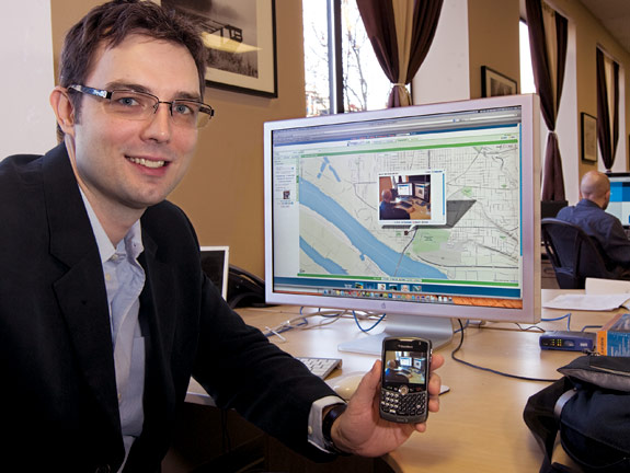
Among its mapping functions, MapWith.Us patented technology allows users of “smart” telephones–BlackBerrys, iPhones, and their kin–to download information through the phones’ Internet connections to a website. The technology automatically “geolocates” postings of text, photos, and other information to the right spot on the electronic map using the phone’s built-in GPS, and is even sophisticated enough to tie multiple postings to a single event based on time and location.
The newspaper plans to add the world’s first real-time map allowing readers to instantly post content from their own phones to a separate map on The Columbian’s forums page, once management is comfortable that a “report abuse” function will allow users to delete offensive content, says Jeff Bunch, the newspaper’s Web editor.
MapWith.Us may push the growing trend toward “citizen journalism” with a mapping twist that Pilskalns expects news and sports media– and their users–to find irresistible.
What started as a classroom exercise has turned into an exciting venture for a teacher and his students who see a bright future for their business. Mapping technology “is a huge area in the industry right now,” says Karpenske. “It seems like we got in here just at the right time.”